Daltonganj geodata
Daltonganj (Jharkhand) is a populated place; located in India in Asia/Kolkata (GMT+5.5) time zone. With population of 77,704 people, there are 562 cities with bigger population in this country. Compared to other cities in India, 58.3% of cities are located further ↓South; 82.1% of cities are located further ←West and 55.1% of cities have lower elevation than Daltonganj. Note1


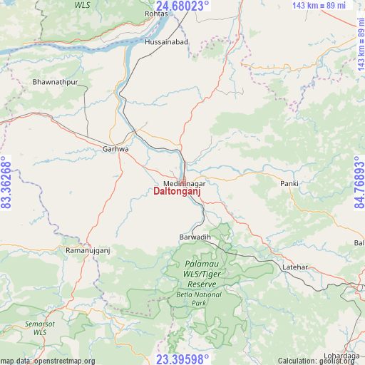
Daltonganj GPS coordinates[2]
24° 2' 22.956" North, 84° 3' 56.88" East
| Map corner | latitude | longitude |
|---|---|---|
| Upper-left | 24.68023°, | 83.36268° |
| Center: | 24.03971°, | 84.0658° |
| Lower-right: | 23.39598°, | 84.76893° |
| Map W x H: | 142.8×142.8 km | = 88.7×88.7mi |
| max Lat: | 34.9274° ⇑41.7% North |
| Daltonganj: | 24.03971° |
| min Lat: | ⇓58.3% South 8.09008° |
| min Long | Daltonganj | max Long |
| 68.82655° | 84.0658° | 96.81° |
| W 82.1%⇐ | ⇒17.9% E |
Elevation
Elevation of Daltonganj is 227 m = 745 ft, and this is 68.6 m = 225 ft below average elevation for this country.
| Max E: |
3681 m = 12077 ft | 44.9% |
| Avg. | 295.6 m = 970 ft | |
| Daltonganj | 227 m = 745 ft | |
Min E: |
1 m = 3 ft | 55.1% |
See also: Daltonganj elevation on elevation.city.
Geographical zone
Daltonganj is located in North temperate zone (between Tropic of Cancer and the Arctic Circle). Distance of this Northern Tropic circle is 67 km =41.6 mi to South.| Distance of | km | miles | from Daltonganj |
|---|---|---|---|
| North Pole | 7334.1 | 4557.2 | to North |
| Arctic Circle | 4728.2 | 2938 | to North |
| Tropic Cancer | 67 | 41.6 | to South |
| Equator | 2673 | 1660.9 | to South |


Nearby cities:
15 places around Daltonganj: (largest is in red/bold)
• Aurangābād
85.1 km =52.9 mi,  21°
21°
• Balrampur
66.3 km =41.2 mi,  224°
224°
• Barwādih
21.8 km =13.5 mi,  167°
167°
• Chatrā
83.8 km =52.1 mi,  77°
77°
• Dehri
96.7 km =60.1 mi,  6°
6°
• Dūdhi
85.9 km =53.4 mi,  283°
283°
• Garhwa
29.4 km =18.3 mi,  297°
297°
• Husainābād
54.8 km =34.1 mi,  353°
353°
• Lohārdagā
92 km =57.2 mi,  137°
137°
• Lātehār
55 km =34.2 mi,  126°
126°
• Nabīnagar
63.4 km =39.4 mi, 5°
• Neturhāt
66.1 km =41.1 mi,  161°
161°
• Rafiganj
103.9 km =64.6 mi,  33°
33°
• Rāmānuj Ganj
45.4 km =28.2 mi,  235°
235°
• Sherghāti
93.5 km =58.1 mi,  51°
51°
Sources, notices
• [Note1] Compared only with cities in India existing in our database
• [Src1] Map data: © OpenStreetMap contributors (CC-BY-SA)
• [Src2] Other city data from geonames.org with taken over terms of usage.
• [Src3] Geographical zone / Annual Mean Temperature by Robert A. Rohde @ Wikipedia
