Nandurbar geodata
Nandurbar (Maharashtra) is a populated place; located in India in Asia/Kolkata (GMT+5.5) time zone. With population of 100,703 people, there are 436 cities with bigger population in this country. Compared to other cities in India, 59.6% of cities are located further ↑North; 88.1% of cities are located further →East and 52.6% of cities have lower elevation than Nandurbar. Note1


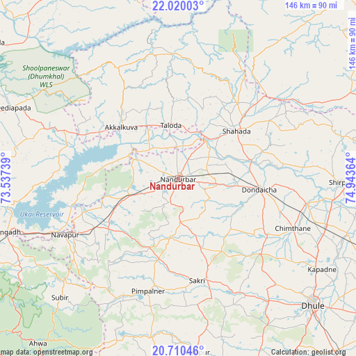
Nandurbar GPS coordinates[2]
21° 22' 0.156" North, 74° 14' 25.836" East
| Map corner | latitude | longitude |
|---|---|---|
| Upper-left | 22.02003°, | 73.53739° |
| Center: | 21.36671°, | 74.24051° |
| Lower-right: | 20.71046°, | 74.94364° |
| Map W x H: | 145.6×145.6 km | = 90.5×90.5mi |
| max Lat: | 34.9274° ⇑59.6% North |
| Nandurbar: | 21.36671° |
| min Lat: | ⇓40.4% South 8.09008° |
| min Long | Nandurbar | max Long |
| 68.82655° | 74.24051° | 96.81° |
| W 11.9%⇐ | ⇒88.1% E |
Elevation
Elevation of Nandurbar is 216 m = 709 ft, and this is 79.6 m = 261 ft below average elevation for this country.
| Max E: |
3681 m = 12077 ft | 47.4% |
| Avg. | 295.6 m = 970 ft | |
| Nandurbar | 216 m = 709 ft | |
Min E: |
1 m = 3 ft | 52.6% |
See also: Nandurbar elevation on elevation.city.
Geographical zone
Nandurbar is located in North Torrid zone (between Equator and Tropic of Cancer). Distance of this Northern Tropic circle is 230.2 km =143 mi to North.| Distance of | km | miles | from Nandurbar |
|---|---|---|---|
| North Pole | 7631.3 | 4741.9 | to North |
| Arctic Circle | 5025.4 | 3122.6 | to North |
| Tropic Cancer | 230.2 | 143 | to North |
| Equator | 2375.8 | 1476.3 | to South |


Nearby cities:
15 places around Nandurbar: (largest is in red/bold)
• Ahwa
88.9 km =55.2 mi,  220°
220°
• Amalner
92.3 km =57.4 mi,  113°
113°
• Dhūlia
76 km =47.2 mi,  132°
132°
• Dondaicha
34.3 km =21.3 mi,  98°
98°
• Kawānt
83.1 km =51.6 mi,  346°
346°
• Khetia
49.2 km =30.6 mi,  46°
46°
• Pānsemāl
57.6 km =35.8 mi,  55°
55°
• Rājpīpla
94.6 km =58.8 mi,  305°
305°
• Satānā
85.9 km =53.4 mi,  182°
182°
• Sendhwa
95.3 km =59.2 mi,  68°
68°
• Shirpur
66.3 km =41.2 mi,  91°
91°
• Shāhāda
31 km =19.3 mi, 50°
• Songadh
73.5 km =45.7 mi,  252°
252°
• Taloda
21.8 km =13.5 mi, 352°
• Vyāra
92.3 km =57.4 mi, 252°
Sources, notices
• [Note1] Compared only with cities in India existing in our database
• [Src1] Map data: © OpenStreetMap contributors (CC-BY-SA)
• [Src2] Other city data from geonames.org with taken over terms of usage.
• [Src3] Geographical zone / Annual Mean Temperature by Robert A. Rohde @ Wikipedia
