Dhanwār geodata
Dhanwār (Jharkhand) is a populated place; located in India in Asia/Kolkata (GMT+5.5) time zone. With population of 8,512 people, there are 3080 cities with bigger population in this country. Compared to other cities in India, 60.1% of cities are located further ↓South; 86.9% of cities are located further ←West and 72.5% of cities have lower elevation than Dhanwār. Note1


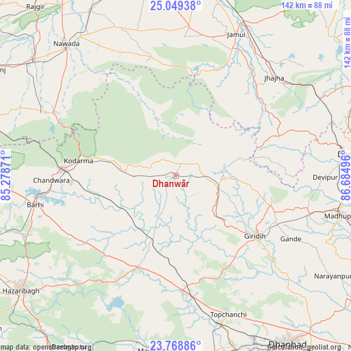
Dhanwār GPS coordinates[2]
24° 24' 38.664" North, 85° 58' 54.588" East
| Map corner | latitude | longitude |
|---|---|---|
| Upper-left | 25.04938°, | 85.27871° |
| Center: | 24.41074°, | 85.98183° |
| Lower-right: | 23.76886°, | 86.68496° |
| Map W x H: | 142.4×142.4 km | = 88.5×88.5mi |
| max Lat: | 34.9274° ⇑39.9% North |
| Dhanwār: | 24.41074° |
| min Lat: | ⇓60.1% South 8.09008° |
| min Long | Dhanwār | max Long |
| 68.82655° | 85.98183° | 96.81° |
| W 86.9%⇐ | ⇒13.1% E |
Elevation
Elevation of Dhanwār is 355 m = 1165 ft, and this is 59.4 m = 195 ft above average elevation for this country.
| Max E: |
3681 m = 12077 ft | 27.5% |
| Dhanwār | 355 m 1165 ft | |
| Avg. | 295.6 m = 970 ft | |
Min E: |
1 m = 3 ft | 72.5% |
See also: India elevation on elevation.city.
Geographical zone
Dhanwār is located in North temperate zone (between Tropic of Cancer and the Arctic Circle). Distance of this Northern Tropic circle is 108.3 km =67.3 mi to South.| Distance of | km | miles | from Dhanwār |
|---|---|---|---|
| North Pole | 7292.8 | 4531.5 | to North |
| Arctic Circle | 4687 | 2912.4 | to North |
| Tropic Cancer | 108.3 | 67.3 | to South |
| Equator | 2714.2 | 1686.5 | to South |


Nearby cities:
15 places around Dhanwār: (largest is in red/bold)
• Barki Saria
27.7 km =17.2 mi,  199°
199°
• Bokāro
69.4 km =43.1 mi,  182°
182°
• Gomoh
62.2 km =38.6 mi,  163°
163°
• Gīrīdīh
41.5 km =25.8 mi,  126°
126°
• Hesla
40 km =24.9 mi, 195°
• Jamūī
62.4 km =38.8 mi,  23°
23°
• Jasidih
68.2 km =42.4 mi,  80°
80°
• Jhā-Jhā
56.7 km =35.2 mi,  45°
45°
• Jumri Tilaiyā
45.9 km =28.5 mi,  273°
273°
• Kodarmā
39.8 km =24.7 mi,  279°
279°
• Madhupur
68.3 km =42.4 mi,  102°
102°
• Nawāda
69 km =42.9 mi,  320°
320°
• Sāruberā
65.9 km =40.9 mi, 178°
• Topchānchi
60.5 km =37.6 mi, 158°
• patamda
58.6 km =36.4 mi,  257°
257°
Sources, notices
• [Note1] Compared only with cities in India existing in our database
• [Src1] Map data: © OpenStreetMap contributors (CC-BY-SA)
• [Src2] Other city data from geonames.org with taken over terms of usage.
• [Src3] Geographical zone / Annual Mean Temperature by Robert A. Rohde @ Wikipedia
