patamda geodata
patamda (Jharkhand) is a populated place; located in India in Asia/Kolkata (GMT+5.5) time zone. With population of 10,655 people, there are 2874 cities with bigger population in this country. Compared to other cities in India, 59.6% of cities are located further ↓South; 85.4% of cities are located further ←West and 75.2% of cities have lower elevation than patamda. Note1


patamda GPS coordinates[2]
24° 18' 0" North, 85° 25' 0.012" East
| Map corner | latitude | longitude |
|---|---|---|
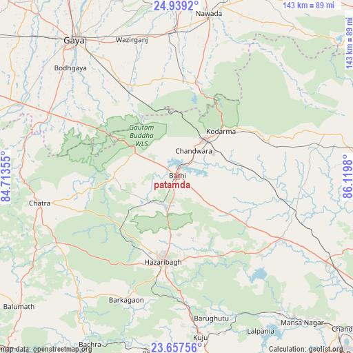
| Upper-left | 24.9392°, | 84.71355° |
| Center: | 24.3°, | 85.41667° |
| Lower-right: | 23.65756°, | 86.1198° |
| Map W x H: | 142.5×142.5 km | = 88.5×88.5mi |
| max Lat: | 34.9274° ⇑40.4% North |
| patamda: | 24.3° |
| min Lat: | ⇓59.6% South 8.09008° |
| min Long | patamda | max Long |
| 68.82655° | 85.41667° | 96.81° |
| W 85.4%⇐ | ⇒14.6% E |
Elevation
Elevation of patamda is 390 m = 1280 ft, and this is 94.4 m = 310 ft above average elevation for this country.
| Max E: |
3681 m = 12077 ft | 24.8% |
| patamda | 390 m 1280 ft | |
| Avg. | 295.6 m = 970 ft | |
Min E: |
1 m = 3 ft | 75.2% |
See also: India elevation on elevation.city.
Geographical zone
patamda is located in North temperate zone (between Tropic of Cancer and the Arctic Circle). Distance of this Northern Tropic circle is 96 km =59.7 mi to South.| Distance of | km | miles | from patamda |
|---|---|---|---|
| North Pole | 7305.2 | 4539.2 | to North |
| Arctic Circle | 4699.3 | 2920 | to North |
| Tropic Cancer | 96 | 59.7 | to South |
| Equator | 2701.9 | 1678.9 | to South |


Nearby cities:
15 places around patamda: (largest is in red/bold)
• Bagaha
44.2 km =27.5 mi,  305°
305°
• Barki Saria
49.9 km =31 mi,  106°
106°
• Buddh Gaya
62 km =38.5 mi,  315°
315°
• Chatrā
56.3 km =35 mi,  259°
259°
• Dhanwār
58.6 km =36.4 mi,  77°
77°
• Gaya
69.2 km =43 mi, 322°
• Gumia
69.6 km =43.2 mi,  143°
143°
• Hazāribāgh
34.7 km =21.6 mi,  189°
189°
• Hesla
53.8 km =33.4 mi,  119°
119°
• Hisuā
59.3 km =36.8 mi,  0°
0°
• Jumri Tilaiyā
18.9 km =11.7 mi,  37°
37°
• Kodarmā
25.9 km =16.1 mi, 43°
• Kuju
64.6 km =40.1 mi,  171°
171°
• Nawāda
66.5 km =41.3 mi,  11°
11°
• Sherghāti
69.5 km =43.2 mi,  294°
294°
Sources, notices
• [Note1] Compared only with cities in India existing in our database
• [Src1] Map data: © OpenStreetMap contributors (CC-BY-SA)
• [Src2] Other city data from geonames.org with taken over terms of usage.
• [Src3] Geographical zone / Annual Mean Temperature by Robert A. Rohde @ Wikipedia
