Jasidih geodata
Jasidih (Jharkhand) is a populated place; located in India in Asia/Kolkata (GMT+5.5) time zone. With population of 16,338 people, there are 2345 cities with bigger population in this country. Compared to other cities in India, 60.8% of cities are located further ↓South; 88.6% of cities are located further ←West and 63.1% of cities have lower elevation than Jasidih. Note1


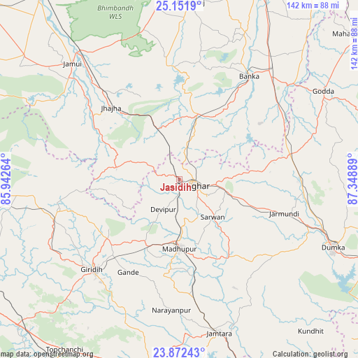
Jasidih GPS coordinates[2]
24° 30' 49.644" North, 86° 38' 44.736" East
| Map corner | latitude | longitude |
|---|---|---|
| Upper-left | 25.1519°, | 85.94264° |
| Center: | 24.51379°, | 86.64576° |
| Lower-right: | 23.87243°, | 87.34889° |
| Map W x H: | 142.3×142.3 km | = 88.4×88.4mi |
| max Lat: | 34.9274° ⇑39.2% North |
| Jasidih: | 24.51379° |
| min Lat: | ⇓60.8% South 8.09008° |
| min Long | Jasidih | max Long |
| 68.82655° | 86.64576° | 96.81° |
| W 88.6%⇐ | ⇒11.4% E |
Elevation
Elevation of Jasidih is 272 m = 892 ft, and this is 23.6 m = 77 ft below average elevation for this country.
| Max E: |
3681 m = 12077 ft | 36.9% |
| Avg. | 295.6 m = 970 ft | |
| Jasidih | 272 m = 892 ft | |
Min E: |
1 m = 3 ft | 63.1% |
See also: India elevation on elevation.city.
Geographical zone
Jasidih is located in North temperate zone (between Tropic of Cancer and the Arctic Circle). Distance of this Northern Tropic circle is 119.8 km =74.4 mi to South.| Distance of | km | miles | from Jasidih |
|---|---|---|---|
| North Pole | 7281.4 | 4524.5 | to North |
| Arctic Circle | 4675.5 | 2905.2 | to North |
| Tropic Cancer | 119.8 | 74.4 | to South |
| Equator | 2725.7 | 1693.7 | to South |


Nearby cities:
15 places around Jasidih: (largest is in red/bold)
• Amarpur
64 km =39.8 mi,  23°
23°
• Asarganj
70.9 km =44.1 mi,  3°
3°
• Bānka
49.5 km =30.8 mi,  34°
34°
• Chittaranjan
77.6 km =48.2 mi,  160°
160°
• Dhanwār
68.2 km =42.4 mi,  260°
260°
• Dumka
66.9 km =41.6 mi,  114°
114°
• Gobindpur
76.5 km =47.5 mi,  189°
189°
• Godda
67 km =41.6 mi,  58°
58°
• Gīrīdīh
49.9 km =31 mi,  223°
223°
• Jamūī
62.5 km =38.8 mi,  317°
317°
• Jhā-Jhā
39.3 km =24.4 mi, 316°
• Jāmtāra
63.3 km =39.3 mi,  165°
165°
• Kharagpur
68.5 km =42.6 mi,  352°
352°
• Madhupur
26.6 km =16.5 mi,  181°
181°
• Nirsā
81.3 km =50.5 mi, 175°
Sources, notices
• [Note1] Compared only with cities in India existing in our database
• [Src1] Map data: © OpenStreetMap contributors (CC-BY-SA)
• [Src2] Other city data from geonames.org with taken over terms of usage.
• [Src3] Geographical zone / Annual Mean Temperature by Robert A. Rohde @ Wikipedia
