Baud geodata
Baud (Odisha) is a populated place; located in India in Asia/Kolkata (GMT+5.5) time zone. With population of 18,945 people, there are 2133 cities with bigger population in this country. Compared to other cities in India, 62.3% of cities are located further ↑North; 82.6% of cities are located further ←West and 69.3% of cities have higher elevation than Baud. Note1


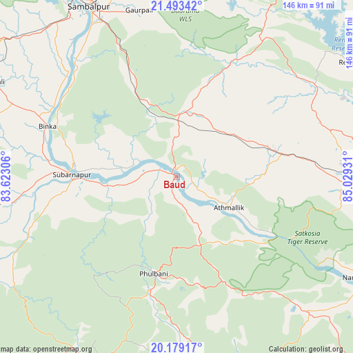
Baud GPS coordinates[2]
20° 50' 15.828" North, 84° 19' 34.248" East
| Map corner | latitude | longitude |
|---|---|---|
| Upper-left | 21.49342°, | 83.62306° |
| Center: | 20.83773°, | 84.32618° |
| Lower-right: | 20.17917°, | 85.02931° |
| Map W x H: | 146.1×146.1 km | = 90.8×90.8mi |
| max Lat: | 34.9274° ⇑62.3% North |
| Baud: | 20.83773° |
| min Lat: | ⇓37.7% South 8.09008° |
| min Long | Baud | max Long |
| 68.82655° | 84.32618° | 96.81° |
| W 82.6%⇐ | ⇒17.4% E |
Elevation
Elevation of Baud is 96 m = 315 ft, and this is 199.6 m = 655 ft below average elevation for this country.
| Max E: |
3681 m = 12077 ft | 69.3% |
| Avg. | 295.6 m = 970 ft | |
| Baud | 96 m = 315 ft | |
Min E: |
1 m = 3 ft | 30.7% |
See also: India elevation on elevation.city.
Geographical zone
Baud is located in North Torrid zone (between Equator and Tropic of Cancer). Distance of this Northern Tropic circle is 289 km =179.6 mi to North.| Distance of | km | miles | from Baud |
|---|---|---|---|
| North Pole | 7690.1 | 4778.4 | to North |
| Arctic Circle | 5084.2 | 3159.2 | to North |
| Tropic Cancer | 289 | 179.6 | to North |
| Equator | 2316.9 | 1439.7 | to South |


Nearby cities:
15 places around Baud: (largest is in red/bold)
• Angul
80.6 km =50.1 mi,  89°
89°
• Balāngīr
88.2 km =54.8 mi,  260°
260°
• Bargarh
91.8 km =57 mi,  306°
306°
• Barpāli
86.1 km =53.5 mi,  297°
297°
• Binka
57.4 km =35.7 mi,  291°
291°
• Burla
88.3 km =54.9 mi,  327°
327°
• Deogarh
88.6 km =55.1 mi,  28°
28°
• Hīrākud
89.7 km =55.7 mi, 328°
• Kaintragarh
25.3 km =15.7 mi,  120°
120°
• Phulbāni
40.9 km =25.4 mi,  194°
194°
• Rengāli
94.2 km =58.5 mi,  342°
342°
• Sambalpur
78.7 km =48.9 mi, 332°
• Sonepur
42.6 km =26.5 mi,  269°
269°
• Tarabha
68.8 km =42.8 mi, 260°
• Udayagiri
79.5 km =49.4 mi,  176°
176°
Sources, notices
• [Note1] Compared only with cities in India existing in our database
• [Src1] Map data: © OpenStreetMap contributors (CC-BY-SA)
• [Src2] Other city data from geonames.org with taken over terms of usage.
• [Src3] Geographical zone / Annual Mean Temperature by Robert A. Rohde @ Wikipedia
