Kaimori geodata
Kaimori (Madhya Pradesh) is a populated place; located in India in Asia/Kolkata (GMT+5.5) time zone. With population of 20,154 people, there are 2028 cities with bigger population in this country. Compared to other cities in India, 54.2% of cities are located further ↓South; 66.2% of cities are located further ←West and 74% of cities have lower elevation than Kaimori. Note1


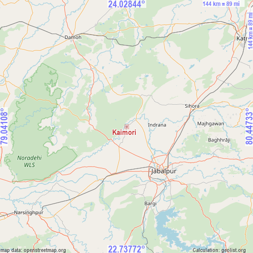
Kaimori GPS coordinates[2]
23° 23' 4.74" North, 79° 44' 39.12" East
| Map corner | latitude | longitude |
|---|---|---|
| Upper-left | 24.02844°, | 79.04108° |
| Center: | 23.38465°, | 79.7442° |
| Lower-right: | 22.73772°, | 80.44733° |
| Map W x H: | 143.5×143.5 km | = 89.2×89.2mi |
| max Lat: | 34.9274° ⇑45.8% North |
| Kaimori: | 23.38465° |
| min Lat: | ⇓54.2% South 8.09008° |
| min Long | Kaimori | max Long |
| 68.82655° | 79.7442° | 96.81° |
| W 66.2%⇐ | ⇒33.8% E |
Elevation
Elevation of Kaimori is 374 m = 1227 ft, and this is 78.4 m = 257 ft above average elevation for this country.
| Max E: |
3681 m = 12077 ft | 26% |
| Kaimori | 374 m 1227 ft | |
| Avg. | 295.6 m = 970 ft | |
Min E: |
1 m = 3 ft | 74% |
See also: India elevation on elevation.city.
Geographical zone
Kaimori is located in North Torrid zone (between Equator and Tropic of Cancer). Distance of this Northern Tropic circle is 5.8 km =3.6 mi to North.| Distance of | km | miles | from Kaimori |
|---|---|---|---|
| North Pole | 7406.9 | 4602.4 | to North |
| Arctic Circle | 4801 | 2983.2 | to North |
| Tropic Cancer | 5.8 | 3.6 | to North |
| Equator | 2600.1 | 1615.6 | to South |


Nearby cities:
15 places around Kaimori: (largest is in red/bold)
• Barela
44.8 km =27.8 mi,  135°
135°
• Bargi
45.7 km =28.4 mi,  162°
162°
• Damoh
58.6 km =36.4 mi,  328°
328°
• Deori Khās
74.3 km =46.2 mi,  270°
270°
• Hindoria
60.4 km =37.5 mi,  342°
342°
• Jabalpur
32.1 km =19.9 mi, 139°
• Katangi
8.2 km =5.1 mi,  40°
40°
• Khamaria
22.5 km =14 mi, 141°
• Majholi
22.5 km =14 mi,  54°
54°
• Panāgar
27.9 km =17.3 mi,  113°
113°
• Pātan
12.3 km =7.6 mi,  207°
207°
• Rehli
74.9 km =46.5 mi,  292°
292°
• Shāhpura
28.8 km =17.9 mi,  196°
196°
• Sihorā
38.4 km =23.9 mi,  72°
72°
• Tendūkheda
20.9 km =13 mi, 273°
Sources, notices
• [Note1] Compared only with cities in India existing in our database
• [Src1] Map data: © OpenStreetMap contributors (CC-BY-SA)
• [Src2] Other city data from geonames.org with taken over terms of usage.
• [Src3] Geographical zone / Annual Mean Temperature by Robert A. Rohde @ Wikipedia
