Rājgarh geodata
Rājgarh (Rajasthan) is a populated place; located in India in Asia/Kolkata (GMT+5.5) time zone. With population of 49,583 people, there are 894 cities with bigger population in this country. Compared to other cities in India, 87.5% of cities are located further ↓South; 79.3% of cities are located further →East and 58.1% of cities have lower elevation than Rājgarh. Note1


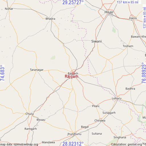
Rājgarh GPS coordinates[2]
28° 38' 31.236" North, 75° 23' 10.032" East
| Map corner | latitude | longitude |
|---|---|---|
| Upper-left | 29.25727°, | 74.683° |
| Center: | 28.64201°, | 75.38612° |
| Lower-right: | 28.02312°, | 76.08925° |
| Map W x H: | 137.2×137.2 km | = 85.3×85.3mi |
| max Lat: | 34.9274° ⇑12.5% North |
| Rājgarh: | 28.64201° |
| min Lat: | ⇓87.5% South 8.09008° |
| min Long | Rājgarh | max Long |
| 68.82655° | 75.38612° | 96.81° |
| W 20.7%⇐ | ⇒79.3% E |
Elevation
Elevation of Rājgarh is 240 m = 787 ft, and this is 55.6 m = 182 ft below average elevation for this country.
| Max E: |
3681 m = 12077 ft | 41.9% |
| Avg. | 295.6 m = 970 ft | |
| Rājgarh | 240 m = 787 ft | |
Min E: |
1 m = 3 ft | 58.1% |
See also: Rājgarh elevation on elevation.city.
Geographical zone
Rājgarh is located in North temperate zone (between Tropic of Cancer and the Arctic Circle). Distance of this Northern Tropic circle is 578.8 km =359.6 mi to South.| Distance of | km | miles | from Rājgarh |
|---|---|---|---|
| North Pole | 6822.4 | 4239.2 | to North |
| Arctic Circle | 4216.5 | 2620 | to North |
| Tropic Cancer | 578.8 | 359.6 | to South |
| Equator | 3184.7 | 1978.9 | to South |


Nearby cities:
15 places around Rājgarh: (largest is in red/bold)
• Bagar
51.7 km =32.1 mi,  167°
167°
• Bhiwāni
75.4 km =46.9 mi,  77°
77°
• Bhādra
55.4 km =34.4 mi,  337°
337°
• Bissāu
53.3 km =33.1 mi,  214°
214°
• Chidawa
51.2 km =31.8 mi,  150°
150°
• Chūru
55.6 km =34.5 mi,  227°
227°
• Hisar
65.7 km =40.8 mi,  29°
29°
• Hānsi
76 km =47.2 mi,  47°
47°
• Jhunjhunūn
57.4 km =35.7 mi,  178°
178°
• Lohāru
47.5 km =29.5 mi,  119°
119°
• Mandholi Kalān
29.9 km =18.6 mi, 75°
• Pilāni
37.2 km =23.1 mi, 145°
• Sūrajgarh
50.1 km =31.1 mi,  137°
137°
• Toshām
57.6 km =35.8 mi,  63°
63°
• Tārānagar
34.7 km =21.6 mi,  274°
274°
Sources, notices
• [Note1] Compared only with cities in India existing in our database
• [Src1] Map data: © OpenStreetMap contributors (CC-BY-SA)
• [Src2] Other city data from geonames.org with taken over terms of usage.
• [Src3] Geographical zone / Annual Mean Temperature by Robert A. Rohde @ Wikipedia
