Pilāni geodata
Pilāni (Rajasthan) is a populated place; located in India in Asia/Kolkata (GMT+5.5) time zone. With population of 28,149 people, there are 1532 cities with bigger population in this country. Compared to other cities in India, 86.2% of cities are located further ↓South; 77.6% of cities are located further →East and 66.4% of cities have lower elevation than Pilāni. Note1


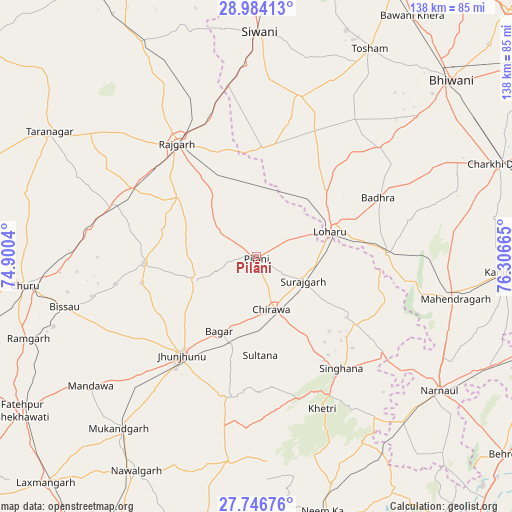
Pilāni GPS coordinates[2]
28° 22' 2.1" North, 75° 36' 12.672" East
| Map corner | latitude | longitude |
|---|---|---|
| Upper-left | 28.98413°, | 74.9004° |
| Center: | 28.36725°, | 75.60352° |
| Lower-right: | 27.74676°, | 76.30665° |
| Map W x H: | 137.6×137.6 km | = 85.5×85.5mi |
| max Lat: | 34.9274° ⇑13.8% North |
| Pilāni: | 28.36725° |
| min Lat: | ⇓86.2% South 8.09008° |
| min Long | Pilāni | max Long |
| 68.82655° | 75.60352° | 96.81° |
| W 22.4%⇐ | ⇒77.6% E |
Elevation
Elevation of Pilāni is 296 m = 971 ft, and this is 0.39999999999998 m = 1 ft above average elevation for this country.
| Max E: |
3681 m = 12077 ft | 33.6% |
| Pilāni | 296 m 971 ft | |
| Avg. | 295.6 m = 970 ft | |
Min E: |
1 m = 3 ft | 66.4% |
See also: India elevation on elevation.city.
Geographical zone
Pilāni is located in North temperate zone (between Tropic of Cancer and the Arctic Circle). Distance of this Northern Tropic circle is 548.2 km =340.6 mi to South.| Distance of | km | miles | from Pilāni |
|---|---|---|---|
| North Pole | 6852.9 | 4258.2 | to North |
| Arctic Circle | 4247 | 2639 | to North |
| Tropic Cancer | 548.2 | 340.6 | to South |
| Equator | 3154.1 | 1959.9 | to South |


Nearby cities:
15 places around Pilāni: (largest is in red/bold)
• Bagar
22.4 km =13.9 mi,  206°
206°
• Bissāu
53.3 km =33.1 mi,  255°
255°
• Chidawa
14.7 km =9.1 mi,  165°
165°
• Chūru
62.7 km =39 mi, 263°
• Jhunjhunūn
33.6 km =20.9 mi,  216°
216°
• Khetri
44.5 km =27.7 mi,  156°
156°
• Lohāru
21.2 km =13.2 mi,  70°
70°
• Mahendragarh
54.8 km =34.1 mi,  101°
101°
• Mandholi Kalān
38.7 km =24 mi,  11°
11°
• Nawalgarh
65.8 km =40.9 mi, 209°
• Nārnaul
61.1 km =38 mi,  125°
125°
• Rājgarh
37.2 km =23.1 mi,  325°
325°
• Sūrajgarh
14.2 km =8.8 mi,  116°
116°
• Toshām
63.7 km =39.6 mi,  28°
28°
• Tārānagar
65.1 km =40.5 mi,  300°
300°
Sources, notices
• [Note1] Compared only with cities in India existing in our database
• [Src1] Map data: © OpenStreetMap contributors (CC-BY-SA)
• [Src2] Other city data from geonames.org with taken over terms of usage.
• [Src3] Geographical zone / Annual Mean Temperature by Robert A. Rohde @ Wikipedia
