Chidawa geodata
Chidawa (Rajasthan) is a populated place; located in India in Asia/Kolkata (GMT+5.5) time zone. With population of 41,319 people, there are 1069 cities with bigger population in this country. Compared to other cities in India, 85.6% of cities are located further ↓South; 77.1% of cities are located further →East and 68.9% of cities have lower elevation than Chidawa. Note1


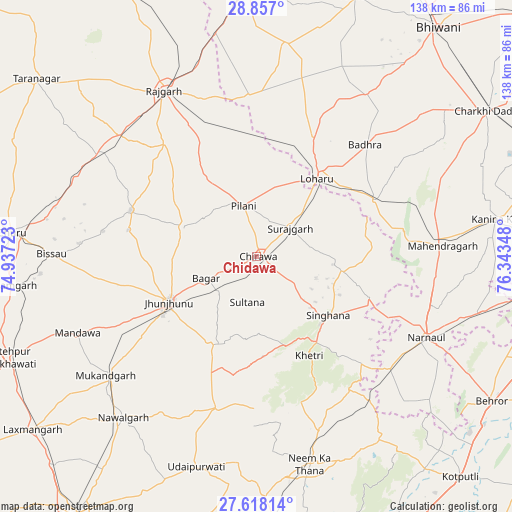
Chidawa GPS coordinates[2]
28° 14' 21.732" North, 75° 38' 25.26" East
| Map corner | latitude | longitude |
|---|---|---|
| Upper-left | 28.857°, | 74.93723° |
| Center: | 28.23937°, | 75.64035° |
| Lower-right: | 27.61814°, | 76.34348° |
| Map W x H: | 137.7×137.7 km | = 85.6×85.6mi |
| max Lat: | 34.9274° ⇑14.4% North |
| Chidawa: | 28.23937° |
| min Lat: | ⇓85.6% South 8.09008° |
| min Long | Chidawa | max Long |
| 68.82655° | 75.64035° | 96.81° |
| W 22.9%⇐ | ⇒77.1% E |
Elevation
Elevation of Chidawa is 316 m = 1037 ft, and this is 20.4 m = 67 ft above average elevation for this country.
| Max E: |
3681 m = 12077 ft | 31.1% |
| Chidawa | 316 m 1037 ft | |
| Avg. | 295.6 m = 970 ft | |
Min E: |
1 m = 3 ft | 68.9% |
See also: Chidawa elevation on elevation.city.
Geographical zone
Chidawa is located in North temperate zone (between Tropic of Cancer and the Arctic Circle). Distance of this Northern Tropic circle is 534 km =331.8 mi to South.| Distance of | km | miles | from Chidawa |
|---|---|---|---|
| North Pole | 6867.1 | 4267 | to North |
| Arctic Circle | 4261.3 | 2647.8 | to North |
| Tropic Cancer | 534 | 331.8 | to South |
| Equator | 3139.9 | 1951 | to South |


Nearby cities:
15 places around Chidawa: (largest is in red/bold)
• Ateli Mandi
62.6 km =38.9 mi,  104°
104°
• Bagar
14.9 km =9.3 mi,  247°
247°
• Bissāu
55.2 km =34.3 mi,  270°
270°
• Jhunjhunūn
26.9 km =16.7 mi,  241°
241°
• Khetri
30.2 km =18.8 mi,  151°
151°
• Lohāru
26.8 km =16.7 mi,  37°
37°
• Mahendragarh
50.3 km =31.3 mi,  86°
86°
• Mandholi Kalān
52.3 km =32.5 mi,  4°
4°
• Nawalgarh
56.1 km =34.9 mi,  219°
219°
• Neem ka Thana
57.4 km =35.7 mi,  165°
165°
• Nārnaul
50.7 km =31.5 mi,  115°
115°
• Pilāni
14.7 km =9.1 mi,  345°
345°
• Rājgarh
51.2 km =31.8 mi,  330°
330°
• Sūrajgarh
12 km =7.5 mi,  49°
49°
• Udaipur
59.8 km =37.2 mi,  196°
196°
Sources, notices
• [Note1] Compared only with cities in India existing in our database
• [Src1] Map data: © OpenStreetMap contributors (CC-BY-SA)
• [Src2] Other city data from geonames.org with taken over terms of usage.
• [Src3] Geographical zone / Annual Mean Temperature by Robert A. Rohde @ Wikipedia
