Vikāsnagar geodata
Vikāsnagar (Uttarakhand) is a populated place; located in India in Asia/Kolkata (GMT+5.5) time zone. With population of 13,055 people, there are 2652 cities with bigger population in this country. Compared to other cities in India, 94.2% of cities are located further ↓South; 54.1% of cities are located further →East and 80.6% of cities have lower elevation than Vikāsnagar. Note1


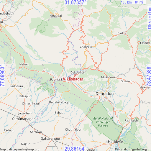
Vikāsnagar GPS coordinates[2]
30° 28' 9.984" North, 77° 46' 21.9" East
| Map corner | latitude | longitude |
|---|---|---|
| Upper-left | 31.07357°, | 77.06963° |
| Center: | 30.46944°, | 77.77275° |
| Lower-right: | 29.86154°, | 78.47588° |
| Map W x H: | 134.8×134.8 km | = 83.8×83.8mi |
| max Lat: | 34.9274° ⇑5.8% North |
| Vikāsnagar: | 30.46944° |
| min Lat: | ⇓94.2% South 8.09008° |
| min Long | Vikāsnagar | max Long |
| 68.82655° | 77.77275° | 96.81° |
| W 45.9%⇐ | ⇒54.1% E |
Elevation
Elevation of Vikāsnagar is 468 m = 1535 ft, and this is 172.4 m = 566 ft above average elevation for this country.
| Max E: |
3681 m = 12077 ft | 19.4% |
| Vikāsnagar | 468 m 1535 ft | |
| Avg. | 295.6 m = 970 ft | |
Min E: |
1 m = 3 ft | 80.6% |
See also: India elevation on elevation.city.
Geographical zone
Vikāsnagar is located in North temperate zone (between Tropic of Cancer and the Arctic Circle). Distance of this Northern Tropic circle is 782 km =485.9 mi to South.| Distance of | km | miles | from Vikāsnagar |
|---|---|---|---|
| North Pole | 6619.2 | 4113 | to North |
| Arctic Circle | 4013.3 | 2493.7 | to North |
| Tropic Cancer | 782 | 485.9 | to South |
| Equator | 3387.9 | 2105.1 | to South |


Nearby cities:
15 places around Vikāsnagar: (largest is in red/bold)
• Behat
36.4 km =22.6 mi,  204°
204°
• Bilāspur
48.5 km =30.1 mi,  247°
247°
• Būriya
52.7 km =32.7 mi,  229°
229°
• Chakrāta
27.5 km =17.1 mi,  18°
18°
• Chaupāl
55.9 km =34.7 mi,  341°
341°
• Chhachhrauli
46.8 km =29.1 mi,  237°
237°
• Chhutmalpur
48.7 km =30.3 mi,  182°
182°
• Clement Town
32.2 km =20 mi,  135°
135°
• Dehra Dūn
29.8 km =18.5 mi,  122°
122°
• Doiwāla
46.4 km =28.8 mi,  134°
134°
• Harbatpur
4.6 km =2.9 mi,  221°
221°
• Mussoorie
28.6 km =17.8 mi,  93°
93°
• Nāhan
46.9 km =29.1 mi,  282°
282°
• Pāonta Sāhib
14.7 km =9.1 mi,  255°
255°
• Rāipur
35.1 km =21.8 mi, 120°
Sources, notices
• [Note1] Compared only with cities in India existing in our database
• [Src1] Map data: © OpenStreetMap contributors (CC-BY-SA)
• [Src2] Other city data from geonames.org with taken over terms of usage.
• [Src3] Geographical zone / Annual Mean Temperature by Robert A. Rohde @ Wikipedia
