Pāonta Sāhib geodata
Pāonta Sāhib (Himachal Pradesh) is a populated place; located in India in Asia/Kolkata (GMT+5.5) time zone. With population of 21,787 people, there are 1915 cities with bigger population in this country. Compared to other cities in India, 94.1% of cities are located further ↓South; 55.7% of cities are located further →East and 76.3% of cities have lower elevation than Pāonta Sāhib. Note1


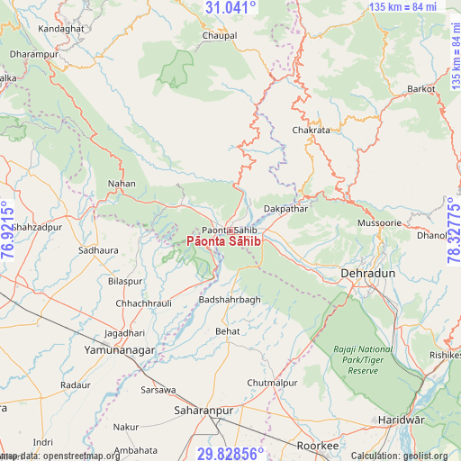
Pāonta Sāhib GPS coordinates[2]
30° 26' 11.976" North, 77° 37' 28.632" East
| Map corner | latitude | longitude |
|---|---|---|
| Upper-left | 31.041°, | 76.9215° |
| Center: | 30.43666°, | 77.62462° |
| Lower-right: | 29.82856°, | 78.32775° |
| Map W x H: | 134.8×134.8 km | = 83.8×83.8mi |
| max Lat: | 34.9274° ⇑5.9% North |
| Pāonta Sāhib: | 30.43666° |
| min Lat: | ⇓94.1% South 8.09008° |
| min Long | Pāonta Sāhib | max Long |
| 68.82655° | 77.62462° | 96.81° |
| W 44.3%⇐ | ⇒55.7% E |
Elevation
Elevation of Pāonta Sāhib is 403 m = 1322 ft, and this is 107.4 m = 352 ft above average elevation for this country.
| Max E: |
3681 m = 12077 ft | 23.7% |
| Pāonta Sāhib | 403 m 1322 ft | |
| Avg. | 295.6 m = 970 ft | |
Min E: |
1 m = 3 ft | 76.3% |
See also: India elevation on elevation.city.
Geographical zone
Pāonta Sāhib is located in North temperate zone (between Tropic of Cancer and the Arctic Circle). Distance of this Northern Tropic circle is 778.3 km =483.6 mi to South.| Distance of | km | miles | from Pāonta Sāhib |
|---|---|---|---|
| North Pole | 6622.8 | 4115.2 | to North |
| Arctic Circle | 4016.9 | 2496 | to North |
| Tropic Cancer | 778.3 | 483.6 | to South |
| Equator | 3384.2 | 2102.8 | to South |


Nearby cities:
15 places around Pāonta Sāhib: (largest is in red/bold)
• Behat
29.5 km =18.3 mi,  182°
182°
• Bilāspur
34.1 km =21.2 mi,  244°
244°
• Būriya
40.1 km =24.9 mi,  219°
219°
• Chakrāta
37.5 km =23.3 mi,  37°
37°
• Chhachhrauli
33.1 km =20.6 mi,  229°
229°
• Chhutmalpur
46.7 km =29 mi,  164°
164°
• Clement Town
41.6 km =25.8 mi,  117°
117°
• Dehra Dūn
41.2 km =25.6 mi,  107°
107°
• Harbatpur
11.1 km =6.9 mi,  88°
88°
• Jagādhri
43 km =26.7 mi, 225°
• Mussoorie
42.8 km =26.6 mi, 87°
• Nāhan
34.5 km =21.4 mi,  293°
293°
• Rāipur
46.8 km =29.1 mi, 107°
• Vikāsnagar
14.7 km =9.1 mi,  75°
75°
• Yamunānagar
47.4 km =29.5 mi, 223°
Sources, notices
• [Note1] Compared only with cities in India existing in our database
• [Src1] Map data: © OpenStreetMap contributors (CC-BY-SA)
• [Src2] Other city data from geonames.org with taken over terms of usage.
• [Src3] Geographical zone / Annual Mean Temperature by Robert A. Rohde @ Wikipedia
