Mussoorie geodata
Mussoorie (Uttarakhand) is a populated place; located in India in Asia/Kolkata (GMT+5.5) time zone. With population of 25,753 people, there are 1652 cities with bigger population in this country. Compared to other cities in India, 94.2% of cities are located further ↓South; 50.6% of cities are located further →East and 99.1% of cities have lower elevation than Mussoorie. Note1


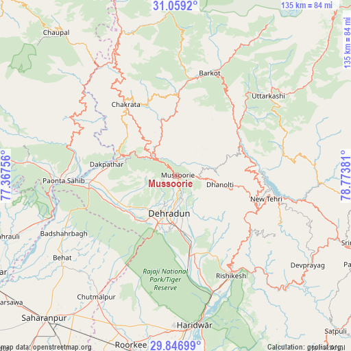
Mussoorie GPS coordinates[2]
30° 27' 17.928" North, 78° 4' 14.448" East
| Map corner | latitude | longitude |
|---|---|---|
| Upper-left | 31.0592°, | 77.36756° |
| Center: | 30.45498°, | 78.07068° |
| Lower-right: | 29.84699°, | 78.77381° |
| Map W x H: | 134.8×134.8 km | = 83.8×83.8mi |
| max Lat: | 34.9274° ⇑5.8% North |
| Mussoorie: | 30.45498° |
| min Lat: | ⇓94.2% South 8.09008° |
| min Long | Mussoorie | max Long |
| 68.82655° | 78.07068° | 96.81° |
| W 49.4%⇐ | ⇒50.6% E |
Elevation
Elevation of Mussoorie is 1824 m = 5984 ft, and this is 1528.4 m = 5014 ft above average elevation for this country.
| Max E: |
3681 m = 12077 ft | 0.90000000000001% |
| Mussoorie | 1824 m 5984 ft | |
| Avg. | 295.6 m = 970 ft | |
Min E: |
1 m = 3 ft | 99.1% |
See also: India elevation on elevation.city.
Geographical zone
Mussoorie is located in North temperate zone (between Tropic of Cancer and the Arctic Circle). Distance of this Northern Tropic circle is 780.4 km =484.9 mi to South.| Distance of | km | miles | from Mussoorie |
|---|---|---|---|
| North Pole | 6620.8 | 4114 | to North |
| Arctic Circle | 4014.9 | 2494.7 | to North |
| Tropic Cancer | 780.4 | 484.9 | to South |
| Equator | 3386.3 | 2104.1 | to South |


Nearby cities:
15 places around Mussoorie: (largest is in red/bold)
• Barkot
41.4 km =25.7 mi,  18°
18°
• Birbhaddar
47.2 km =29.3 mi,  154°
154°
• Chakrāta
34 km =21.1 mi,  324°
324°
• Clement Town
22.1 km =13.7 mi,  195°
195°
• Dehra Dūn
14.9 km =9.3 mi,  193°
193°
• Doiwāla
31.3 km =19.4 mi,  171°
171°
• Harbatpur
31.7 km =19.7 mi,  266°
266°
• Narendranagar
38.7 km =24 mi, 147°
• Pāonta Sāhib
42.8 km =26.6 mi, 267°
• Rishīkesh
44.1 km =27.4 mi, 151°
• Rāipur
16.1 km =10 mi, 173°
• Rāīwāla Bara
50.9 km =31.6 mi,  162°
162°
• Tehri
39.9 km =24.8 mi,  100°
100°
• Uttarkāshi
47 km =29.2 mi,  49°
49°
• Vikāsnagar
28.6 km =17.8 mi, 273°
Sources, notices
• [Note1] Compared only with cities in India existing in our database
• [Src1] Map data: © OpenStreetMap contributors (CC-BY-SA)
• [Src2] Other city data from geonames.org with taken over terms of usage.
• [Src3] Geographical zone / Annual Mean Temperature by Robert A. Rohde @ Wikipedia
