Chakrāta geodata
Chakrāta (Uttarakhand) is a populated place; located in India in Asia/Kolkata (GMT+5.5) time zone. With population of 3,348 people, there are 3400 cities with bigger population in this country. Compared to other cities in India, 94.9% of cities are located further ↓South; 52.9% of cities are located further →East and 99.5% of cities have lower elevation than Chakrāta. Note1


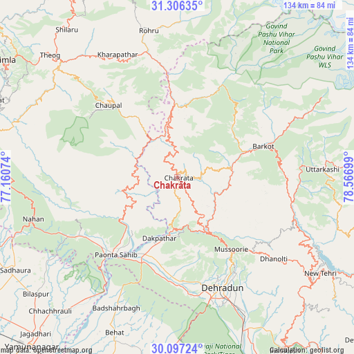
Chakrāta GPS coordinates[2]
30° 42' 13.284" North, 77° 51' 49.896" East
| Map corner | latitude | longitude |
|---|---|---|
| Upper-left | 31.30635°, | 77.16074° |
| Center: | 30.70369°, | 77.86386° |
| Lower-right: | 30.09724°, | 78.56699° |
| Map W x H: | 134.4×134.4 km | = 83.5×83.5mi |
| max Lat: | 34.9274° ⇑5.1% North |
| Chakrāta: | 30.70369° |
| min Lat: | ⇓94.9% South 8.09008° |
| min Long | Chakrāta | max Long |
| 68.82655° | 77.86386° | 96.81° |
| W 47.1%⇐ | ⇒52.9% E |
Elevation
Elevation of Chakrāta is 2110 m = 6923 ft, and this is 1814.4 m = 5953 ft above average elevation for this country.
| Max E: |
3681 m = 12077 ft | 0.5% |
| Chakrāta | 2110 m 6923 ft | |
| Avg. | 295.6 m = 970 ft | |
Min E: |
1 m = 3 ft | 99.5% |
See also: India elevation on elevation.city.
Geographical zone
Chakrāta is located in North temperate zone (between Tropic of Cancer and the Arctic Circle). Distance of this Northern Tropic circle is 808 km =502.1 mi to South.| Distance of | km | miles | from Chakrāta |
|---|---|---|---|
| North Pole | 6593.1 | 4096.8 | to North |
| Arctic Circle | 3987.2 | 2477.5 | to North |
| Tropic Cancer | 808 | 502.1 | to South |
| Equator | 3413.9 | 2121.3 | to South |


Nearby cities:
15 places around Chakrāta: (largest is in red/bold)
• Barkot
34.7 km =21.6 mi,  70°
70°
• Chaupāl
37.7 km =23.4 mi,  315°
315°
• Clement Town
50.9 km =31.6 mi,  164°
164°
• Dehra Dūn
45.2 km =28.1 mi, 158°
• Harbatpur
31.7 km =19.7 mi,  201°
201°
• Jubbal
49.5 km =30.8 mi,  335°
335°
• Kotkhai
55.4 km =34.4 mi,  326°
326°
• Mussoorie
34 km =21.1 mi,  144°
144°
• Nāhan
56.8 km =35.3 mi,  253°
253°
• Pāonta Sāhib
37.5 km =23.3 mi,  217°
217°
• Rohru
56.4 km =35 mi,  349°
349°
• Rāipur
48.7 km =30.3 mi,  153°
153°
• Rājgarh
56.3 km =35 mi,  286°
286°
• Uttarkāshi
55.5 km =34.5 mi,  86°
86°
• Vikāsnagar
27.5 km =17.1 mi, 198°
Sources, notices
• [Note1] Compared only with cities in India existing in our database
• [Src1] Map data: © OpenStreetMap contributors (CC-BY-SA)
• [Src2] Other city data from geonames.org with taken over terms of usage.
• [Src3] Geographical zone / Annual Mean Temperature by Robert A. Rohde @ Wikipedia
