Bhīlwāra geodata
Bhīlwāra (Rajasthan) is a populated place; located in India in Asia/Kolkata (GMT+5.5) time zone. With population of 326,431 people, there are 132 cities with bigger population in this country. Compared to other cities in India, 65.6% of cities are located further ↓South; 85.7% of cities are located further →East and 77.3% of cities have lower elevation than Bhīlwāra. Note1


Bhīlwāra GPS coordinates[2]
25° 20' 49.452" North, 74° 38' 26.916" East
| Map corner | latitude | longitude |
|---|---|---|
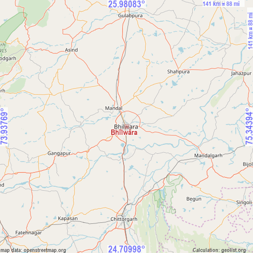
| Upper-left | 25.98083°, | 73.93769° |
| Center: | 25.34707°, | 74.64081° |
| Lower-right: | 24.70998°, | 75.34394° |
| Map W x H: | 141.3×141.3 km | = 87.8×87.8mi |
| max Lat: | 34.9274° ⇑34.4% North |
| Bhīlwāra: | 25.34707° |
| min Lat: | ⇓65.6% South 8.09008° |
| min Long | Bhīlwāra | max Long |
| 68.82655° | 74.64081° | 96.81° |
| W 14.3%⇐ | ⇒85.7% E |
Elevation
Elevation of Bhīlwāra is 419 m = 1375 ft, and this is 123.4 m = 405 ft above average elevation for this country.
| Max E: |
3681 m = 12077 ft | 22.7% |
| Bhīlwāra | 419 m 1375 ft | |
| Avg. | 295.6 m = 970 ft | |
Min E: |
1 m = 3 ft | 77.3% |
See also: Bhīlwāra elevation on elevation.city.
Geographical zone
Bhīlwāra is located in North temperate zone (between Tropic of Cancer and the Arctic Circle). Distance of this Northern Tropic circle is 212.4 km =132 mi to South.| Distance of | km | miles | from Bhīlwāra |
|---|---|---|---|
| North Pole | 7188.7 | 4466.8 | to North |
| Arctic Circle | 4582.8 | 2847.6 | to North |
| Tropic Cancer | 212.4 | 132 | to South |
| Equator | 2818.3 | 1751.2 | to South |


Nearby cities:
15 places around Bhīlwāra: (largest is in red/bold)
• Amet
72 km =44.7 mi,  266°
266°
• Begūn
54.2 km =33.7 mi,  138°
138°
• Chittaurgarh
50.9 km =31.6 mi,  181°
181°
• Dariba
67.5 km =41.9 mi,  229°
229°
• Devgarh
76.2 km =47.3 mi,  285°
285°
• Gangāpur
40.8 km =25.4 mi,  249°
249°
• Gulābpura
62 km =38.5 mi,  1°
1°
• Jahāzpur
70.6 km =43.9 mi,  64°
64°
• Māndal
12.7 km =7.9 mi,  325°
325°
• Māndalgarh
46.6 km =29 mi,  111°
111°
• Nīmbāhera
80.8 km =50.2 mi, 177°
• Ratangarh
76 km =47.2 mi, 140°
• Shāhpura
41.7 km =25.9 mi,  43°
43°
• Singoli
78.7 km =48.9 mi,  122°
122°
• Āsind
53 km =32.9 mi,  324°
324°
Sources, notices
• [Note1] Compared only with cities in India existing in our database
• [Src1] Map data: © OpenStreetMap contributors (CC-BY-SA)
• [Src2] Other city data from geonames.org with taken over terms of usage.
• [Src3] Geographical zone / Annual Mean Temperature by Robert A. Rohde @ Wikipedia
