Māndal geodata
Māndal (Rajasthan) is a populated place; located in India in Asia/Kolkata (GMT+5.5) time zone. With population of 23,478 people, there are 1803 cities with bigger population in this country. Compared to other cities in India, 66.4% of cities are located further ↓South; 86.3% of cities are located further →East and 78.5% of cities have lower elevation than Māndal. Note1


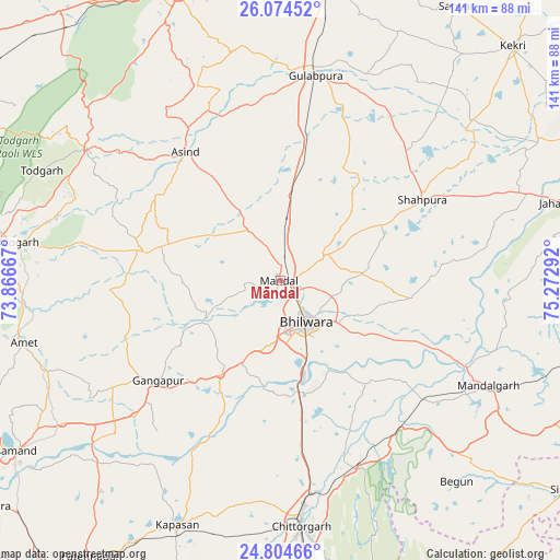
Māndal GPS coordinates[2]
25° 26' 28.536" North, 74° 34' 11.244" East
| Map corner | latitude | longitude |
|---|---|---|
| Upper-left | 26.07452°, | 73.86667° |
| Center: | 25.44126°, | 74.56979° |
| Lower-right: | 24.80466°, | 75.27292° |
| Map W x H: | 141.2×141.2 km | = 87.7×87.7mi |
| max Lat: | 34.9274° ⇑33.6% North |
| Māndal: | 25.44126° |
| min Lat: | ⇓66.4% South 8.09008° |
| min Long | Māndal | max Long |
| 68.82655° | 74.56979° | 96.81° |
| W 13.7%⇐ | ⇒86.3% E |
Elevation
Elevation of Māndal is 437 m = 1434 ft, and this is 141.4 m = 464 ft above average elevation for this country.
| Max E: |
3681 m = 12077 ft | 21.5% |
| Māndal | 437 m 1434 ft | |
| Avg. | 295.6 m = 970 ft | |
Min E: |
1 m = 3 ft | 78.5% |
See also: India elevation on elevation.city.
Geographical zone
Māndal is located in North temperate zone (between Tropic of Cancer and the Arctic Circle). Distance of this Northern Tropic circle is 222.9 km =138.5 mi to South.| Distance of | km | miles | from Māndal |
|---|---|---|---|
| North Pole | 7178.3 | 4460.4 | to North |
| Arctic Circle | 4572.4 | 2841.2 | to North |
| Tropic Cancer | 222.9 | 138.5 | to South |
| Equator | 2828.8 | 1757.7 | to South |


Nearby cities:
15 places around Māndal: (largest is in red/bold)
• Amet
66.4 km =41.3 mi,  256°
256°
• Begūn
66.8 km =41.5 mi,  139°
139°
• Beāwar
77.5 km =48.2 mi,  341°
341°
• Bhīlwāra
12.7 km =7.9 mi,  145°
145°
• Chittaurgarh
61.6 km =38.3 mi,  174°
174°
• Dariba
70.1 km =43.6 mi,  218°
218°
• Devgarh
67.1 km =41.7 mi,  278°
278°
• Gangāpur
39.7 km =24.7 mi,  231°
231°
• Gulābpura
52.3 km =32.5 mi,  9°
9°
• Jahāzpur
73.6 km =45.7 mi,  74°
74°
• Māndalgarh
57.5 km =35.7 mi,  118°
118°
• Rājsamand
80.7 km =50.1 mi,  239°
239°
• Sarwār
82 km =51 mi,  32°
32°
• Shāhpura
40.8 km =25.4 mi,  60°
60°
• Āsind
40.3 km =25 mi,  323°
323°
Sources, notices
• [Note1] Compared only with cities in India existing in our database
• [Src1] Map data: © OpenStreetMap contributors (CC-BY-SA)
• [Src2] Other city data from geonames.org with taken over terms of usage.
• [Src3] Geographical zone / Annual Mean Temperature by Robert A. Rohde @ Wikipedia
