Gangāpur geodata
Gangāpur (Rajasthan) is a populated place; located in India in Asia/Kolkata (GMT+5.5) time zone. With population of 17,661 people, there are 2225 cities with bigger population in this country. Compared to other cities in India, 64.7% of cities are located further ↓South; 88% of cities are located further →East and 83% of cities have lower elevation than Gangāpur. Note1


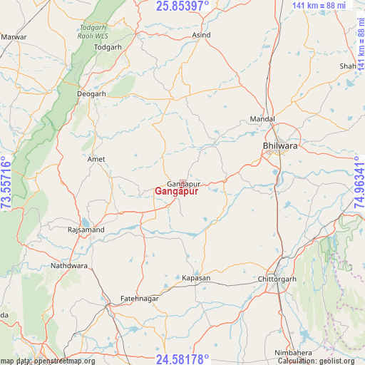
Gangāpur GPS coordinates[2]
25° 13' 10.344" North, 74° 15' 37.008" East
| Map corner | latitude | longitude |
|---|---|---|
| Upper-left | 25.85397°, | 73.55716° |
| Center: | 25.21954°, | 74.26028° |
| Lower-right: | 24.58178°, | 74.96341° |
| Map W x H: | 141.5×141.5 km | = 87.9×87.9mi |
| max Lat: | 34.9274° ⇑35.3% North |
| Gangāpur: | 25.21954° |
| min Lat: | ⇓64.7% South 8.09008° |
| min Long | Gangāpur | max Long |
| 68.82655° | 74.26028° | 96.81° |
| W 12%⇐ | ⇒88% E |
Elevation
Elevation of Gangāpur is 508 m = 1667 ft, and this is 212.4 m = 697 ft above average elevation for this country.
| Max E: |
3681 m = 12077 ft | 17% |
| Gangāpur | 508 m 1667 ft | |
| Avg. | 295.6 m = 970 ft | |
Min E: |
1 m = 3 ft | 83% |
See also: India elevation on elevation.city.
Geographical zone
Gangāpur is located in North temperate zone (between Tropic of Cancer and the Arctic Circle). Distance of this Northern Tropic circle is 198.2 km =123.2 mi to South.| Distance of | km | miles | from Gangāpur |
|---|---|---|---|
| North Pole | 7202.9 | 4475.7 | to North |
| Arctic Circle | 4597 | 2856.4 | to North |
| Tropic Cancer | 198.2 | 123.2 | to South |
| Equator | 2804.1 | 1742.4 | to South |


Nearby cities:
15 places around Gangāpur: (largest is in red/bold)
• Amet
35 km =21.7 mi,  285°
285°
• Begūn
79 km =49.1 mi,  109°
109°
• Bhindār
80.1 km =49.8 mi,  185°
185°
• Bhīlwāra
40.8 km =25.4 mi,  69°
69°
• Chittaurgarh
51.8 km =32.2 mi,  135°
135°
• Dariba
32.7 km =20.3 mi,  202°
202°
• Devgarh
49.1 km =30.5 mi,  313°
313°
• Māndal
39.7 km =24.7 mi,  51°
51°
• Māndalgarh
81.7 km =50.8 mi,  91°
91°
• Nāthdwāra
54 km =33.6 mi,  234°
234°
• Nīmbāhera
78.8 km =49 mi,  147°
147°
• Rājsamand
41.7 km =25.9 mi,  246°
246°
• Shāhpura
80.3 km =49.9 mi,  56°
56°
• Sādri
81.3 km =50.5 mi,  267°
267°
• Āsind
57.7 km =35.9 mi,  7°
7°
Sources, notices
• [Note1] Compared only with cities in India existing in our database
• [Src1] Map data: © OpenStreetMap contributors (CC-BY-SA)
• [Src2] Other city data from geonames.org with taken over terms of usage.
• [Src3] Geographical zone / Annual Mean Temperature by Robert A. Rohde @ Wikipedia
