Dariba geodata
Dariba (Rajasthan) is a populated place; located in India in Asia/Kolkata (GMT+5.5) time zone. With population of 3,076 people, there are 3410 cities with bigger population in this country. Compared to other cities in India, 63.2% of cities are located further ↓South; 88.7% of cities are located further →East and 82.1% of cities have lower elevation than Dariba. Note1


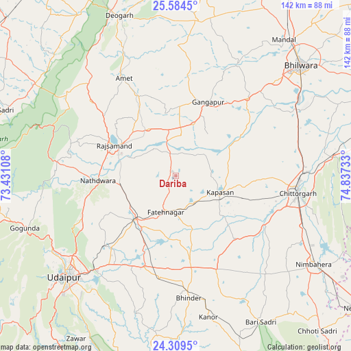
Dariba GPS coordinates[2]
24° 56' 55.14" North, 74° 8' 3.12" East
| Map corner | latitude | longitude |
|---|---|---|
| Upper-left | 25.5845°, | 73.43108° |
| Center: | 24.94865°, | 74.1342° |
| Lower-right: | 24.3095°, | 74.83733° |
| Map W x H: | 141.8×141.8 km | = 88.1×88.1mi |
| max Lat: | 34.9274° ⇑36.8% North |
| Dariba: | 24.94865° |
| min Lat: | ⇓63.2% South 8.09008° |
| min Long | Dariba | max Long |
| 68.82655° | 74.1342° | 96.81° |
| W 11.3%⇐ | ⇒88.7% E |
Elevation
Elevation of Dariba is 494 m = 1621 ft, and this is 198.4 m = 651 ft above average elevation for this country.
| Max E: |
3681 m = 12077 ft | 17.9% |
| Dariba | 494 m 1621 ft | |
| Avg. | 295.6 m = 970 ft | |
Min E: |
1 m = 3 ft | 82.1% |
See also: India elevation on elevation.city.
Geographical zone
Dariba is located in North temperate zone (between Tropic of Cancer and the Arctic Circle). Distance of this Northern Tropic circle is 168.1 km =104.5 mi to South.| Distance of | km | miles | from Dariba |
|---|---|---|---|
| North Pole | 7233 | 4494.4 | to North |
| Arctic Circle | 4627.1 | 2875.1 | to North |
| Tropic Cancer | 168.1 | 104.5 | to South |
| Equator | 2774 | 1723.7 | to South |


Nearby cities:
15 places around Dariba: (largest is in red/bold)
• Amet
44.9 km =27.9 mi,  332°
332°
• Bari Sādri
68.7 km =42.7 mi,  150°
150°
• Bhindār
49.9 km =31 mi,  174°
174°
• Bhīlwāra
67.5 km =41.9 mi,  49°
49°
• Chittaurgarh
49.8 km =30.9 mi,  97°
97°
• Devgarh
68 km =42.3 mi,  340°
340°
• Gangāpur
32.7 km =20.3 mi,  22°
22°
• Jāwad
83.2 km =51.7 mi,  117°
117°
• Kānor
58.7 km =36.5 mi, 166°
• Māndal
70.1 km =43.6 mi,  38°
38°
• Nāthdwāra
31.3 km =19.4 mi,  267°
267°
• Nīmbāhera
66 km =41 mi, 123°
• Rājsamand
29 km =18 mi,  298°
298°
• Sādri
73.5 km =45.7 mi,  290°
290°
• Udaipur
58.6 km =36.4 mi,  226°
226°
Sources, notices
• [Note1] Compared only with cities in India existing in our database
• [Src1] Map data: © OpenStreetMap contributors (CC-BY-SA)
• [Src2] Other city data from geonames.org with taken over terms of usage.
• [Src3] Geographical zone / Annual Mean Temperature by Robert A. Rohde @ Wikipedia
