Badarwās geodata
Badarwās (Madhya Pradesh) is a populated place; located in India in Asia/Kolkata (GMT+5.5) time zone. With population of 11,133 people, there are 2822 cities with bigger population in this country. Compared to other cities in India, 63.3% of cities are located further ↓South; 56.4% of cities are located further →East and 80% of cities have lower elevation than Badarwās. Note1


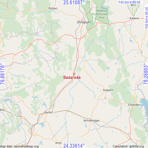
Badarwās GPS coordinates[2]
24° 58' 30.576" North, 77° 33' 53.64" East
| Map corner | latitude | longitude |
|---|---|---|
| Upper-left | 25.61087°, | 76.86178° |
| Center: | 24.97516°, | 77.5649° |
| Lower-right: | 24.33614°, | 78.26803° |
| Map W x H: | 141.7×141.7 km | = 88×88mi |
| max Lat: | 34.9274° ⇑36.7% North |
| Badarwās: | 24.97516° |
| min Lat: | ⇓63.3% South 8.09008° |
| min Long | Badarwās | max Long |
| 68.82655° | 77.5649° | 96.81° |
| W 43.6%⇐ | ⇒56.4% E |
Elevation
Elevation of Badarwās is 460 m = 1509 ft, and this is 164.4 m = 539 ft above average elevation for this country.
| Max E: |
3681 m = 12077 ft | 20% |
| Badarwās | 460 m 1509 ft | |
| Avg. | 295.6 m = 970 ft | |
Min E: |
1 m = 3 ft | 80% |
See also: India elevation on elevation.city.
Geographical zone
Badarwās is located in North temperate zone (between Tropic of Cancer and the Arctic Circle). Distance of this Northern Tropic circle is 171.1 km =106.3 mi to South.| Distance of | km | miles | from Badarwās |
|---|---|---|---|
| North Pole | 7230.1 | 4492.6 | to North |
| Arctic Circle | 4624.2 | 2873.3 | to North |
| Tropic Cancer | 171.1 | 106.3 | to South |
| Equator | 2777 | 1725.5 | to South |


Nearby cities:
15 places around Badarwās: (largest is in red/bold)
• Ashoknagar
47.5 km =29.5 mi,  159°
159°
• Bijrauni
9.2 km =5.7 mi,  120°
120°
• Bāmor Kalān
59.8 km =37.2 mi,  98°
98°
• Chanderi
64.8 km =40.3 mi, 116°
• Chhabra
80.5 km =50 mi,  244°
244°
• Guna
44.6 km =27.7 mi,  215°
215°
• Isāgarh
35.4 km =22 mi, 115°
• Karera
78.6 km =48.8 mi,  46°
46°
• Kolāras
27.5 km =17.1 mi,  9°
9°
• Kumbhrāj
84.9 km =52.8 mi, 217°
• Mungaoli
82.8 km =51.4 mi,  139°
139°
• Narwar
82.2 km =51.1 mi,  25°
25°
• Rāghogarh
69.8 km =43.4 mi,  212°
212°
• Shivpuri
50.8 km =31.6 mi, 11°
• Āron
67.7 km =42.1 mi,  192°
192°
Sources, notices
• [Note1] Compared only with cities in India existing in our database
• [Src1] Map data: © OpenStreetMap contributors (CC-BY-SA)
• [Src2] Other city data from geonames.org with taken over terms of usage.
• [Src3] Geographical zone / Annual Mean Temperature by Robert A. Rohde @ Wikipedia
