Ashoknagar geodata
Ashoknagar (Madhya Pradesh) is a populated place; located in India in Asia/Kolkata (GMT+5.5) time zone. With population of 64,722 people, there are 678 cities with bigger population in this country. Compared to other cities in India, 61.1% of cities are located further ↓South; 54.6% of cities are located further →East and 82.9% of cities have lower elevation than Ashoknagar. Note1


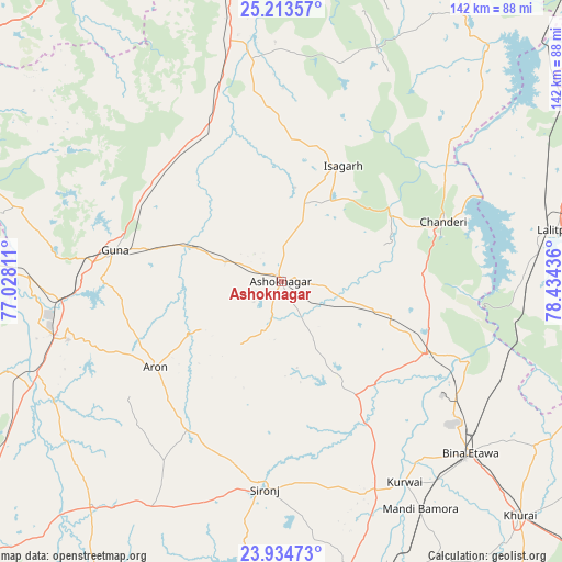
Ashoknagar GPS coordinates[2]
24° 34' 32.808" North, 77° 43' 52.428" East
| Map corner | latitude | longitude |
|---|---|---|
| Upper-left | 25.21357°, | 77.02811° |
| Center: | 24.57578°, | 77.73123° |
| Lower-right: | 23.93473°, | 78.43436° |
| Map W x H: | 142.2×142.2 km | = 88.4×88.4mi |
| max Lat: | 34.9274° ⇑38.9% North |
| Ashoknagar: | 24.57578° |
| min Lat: | ⇓61.1% South 8.09008° |
| min Long | Ashoknagar | max Long |
| 68.82655° | 77.73123° | 96.81° |
| W 45.4%⇐ | ⇒54.6% E |
Elevation
Elevation of Ashoknagar is 504 m = 1654 ft, and this is 208.4 m = 684 ft above average elevation for this country.
| Max E: |
3681 m = 12077 ft | 17.1% |
| Ashoknagar | 504 m 1654 ft | |
| Avg. | 295.6 m = 970 ft | |
Min E: |
1 m = 3 ft | 82.9% |
See also: Ashoknagar elevation on elevation.city.
Geographical zone
Ashoknagar is located in North temperate zone (between Tropic of Cancer and the Arctic Circle). Distance of this Northern Tropic circle is 126.7 km =78.7 mi to South.| Distance of | km | miles | from Ashoknagar |
|---|---|---|---|
| North Pole | 7274.5 | 4520.2 | to North |
| Arctic Circle | 4668.6 | 2900.9 | to North |
| Tropic Cancer | 126.7 | 78.7 | to South |
| Equator | 2732.6 | 1698 | to South |


Nearby cities:
15 places around Ashoknagar: (largest is in red/bold)
• Badarwās
47.5 km =29.5 mi,  339°
339°
• Bamora
68.3 km =42.4 mi,  147°
147°
• Bijrauni
40.7 km =25.3 mi,  347°
347°
• Bāmor Kalān
55.1 km =34.2 mi,  50°
50°
• Chanderi
43.9 km =27.3 mi,  69°
69°
• Etāwa
64.7 km =40.2 mi,  132°
132°
• Guna
43.2 km =26.8 mi,  280°
280°
• Isāgarh
33 km =20.5 mi,  27°
27°
• Korwai
59.8 km =37.2 mi, 148°
• Leteri
66 km =41 mi,  209°
209°
• Mungaoli
41.3 km =25.7 mi,  116°
116°
• Pāli
69.9 km =43.4 mi,  97°
97°
• Rāghogarh
56 km =34.8 mi,  254°
254°
• Sironj
52.7 km =32.7 mi,  184°
184°
• Āron
38.4 km =23.9 mi,  235°
235°
Sources, notices
• [Note1] Compared only with cities in India existing in our database
• [Src1] Map data: © OpenStreetMap contributors (CC-BY-SA)
• [Src2] Other city data from geonames.org with taken over terms of usage.
• [Src3] Geographical zone / Annual Mean Temperature by Robert A. Rohde @ Wikipedia
