Bijrauni geodata
Bijrauni (Madhya Pradesh) is a populated place; located in India in Asia/Kolkata (GMT+5.5) time zone. With population of 5,743 people, there are 3303 cities with bigger population in this country. Compared to other cities in India, 63.2% of cities are located further ↓South; 55.6% of cities are located further →East and 80.1% of cities have lower elevation than Bijrauni. Note1


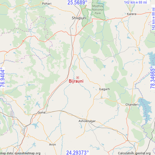
Bijrauni GPS coordinates[2]
24° 55' 58.656" North, 77° 38' 36.672" East
| Map corner | latitude | longitude |
|---|---|---|
| Upper-left | 25.5689°, | 76.9404° |
| Center: | 24.93296°, | 77.64352° |
| Lower-right: | 24.29373°, | 78.34665° |
| Map W x H: | 141.8×141.8 km | = 88.1×88.1mi |
| max Lat: | 34.9274° ⇑36.8% North |
| Bijrauni: | 24.93296° |
| min Lat: | ⇓63.2% South 8.09008° |
| min Long | Bijrauni | max Long |
| 68.82655° | 77.64352° | 96.81° |
| W 44.4%⇐ | ⇒55.6% E |
Elevation
Elevation of Bijrauni is 462 m = 1516 ft, and this is 166.4 m = 546 ft above average elevation for this country.
| Max E: |
3681 m = 12077 ft | 19.9% |
| Bijrauni | 462 m 1516 ft | |
| Avg. | 295.6 m = 970 ft | |
Min E: |
1 m = 3 ft | 80.1% |
See also: India elevation on elevation.city.
Geographical zone
Bijrauni is located in North temperate zone (between Tropic of Cancer and the Arctic Circle). Distance of this Northern Tropic circle is 166.4 km =103.4 mi to South.| Distance of | km | miles | from Bijrauni |
|---|---|---|---|
| North Pole | 7234.8 | 4495.5 | to North |
| Arctic Circle | 4628.9 | 2876.3 | to North |
| Tropic Cancer | 166.4 | 103.4 | to South |
| Equator | 2772.3 | 1722.6 | to South |


Nearby cities:
15 places around Bijrauni: (largest is in red/bold)
• Ashoknagar
40.7 km =25.3 mi,  167°
167°
• Badarwās
9.2 km =5.7 mi,  300°
300°
• Bāmor Kalān
51.4 km =31.9 mi,  94°
94°
• Chanderi
55.6 km =34.5 mi,  116°
116°
• Guna
46.2 km =28.7 mi,  226°
226°
• Isāgarh
26.3 km =16.3 mi,  113°
113°
• Karera
76.6 km =47.6 mi,  40°
40°
• Kolāras
32 km =19.9 mi,  354°
354°
• Lalitpur
82.8 km =51.4 mi, 109°
• Mungaoli
74.1 km =46 mi,  141°
141°
• Narwar
83.6 km =51.9 mi,  18°
18°
• Rāghogarh
70.7 km =43.9 mi,  219°
219°
• Shivpuri
54.6 km =33.9 mi,  1°
1°
• Tālbahat
80.7 km =50.1 mi,  81°
81°
• Āron
65.5 km =40.7 mi,  200°
200°
Sources, notices
• [Note1] Compared only with cities in India existing in our database
• [Src1] Map data: © OpenStreetMap contributors (CC-BY-SA)
• [Src2] Other city data from geonames.org with taken over terms of usage.
• [Src3] Geographical zone / Annual Mean Temperature by Robert A. Rohde @ Wikipedia
