Siwān geodata
Siwān (Bihar) is a populated place; located in India in Asia/Kolkata (GMT+5.5) time zone. With population of 119,181 people, there are 369 cities with bigger population in this country. Compared to other cities in India, 72.1% of cities are located further ↓South; 82.7% of cities are located further ←West and 74.4% of cities have higher elevation than Siwān. Note1


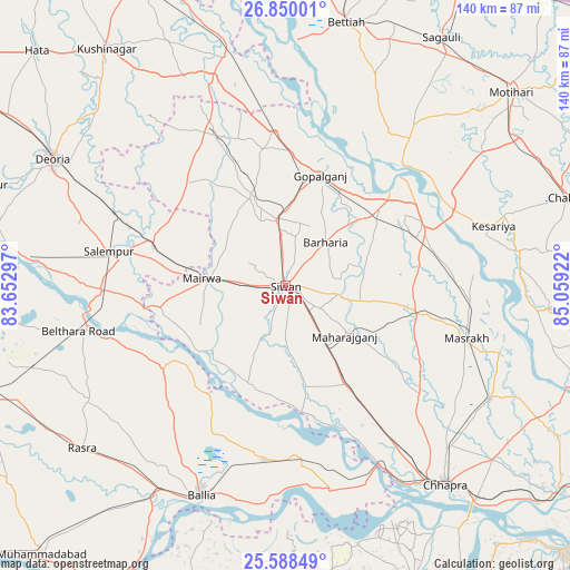
Siwān GPS coordinates[2]
26° 13' 15.456" North, 84° 21' 21.924" East
| Map corner | latitude | longitude |
|---|---|---|
| Upper-left | 26.85001°, | 83.65297° |
| Center: | 26.22096°, | 84.35609° |
| Lower-right: | 25.58849°, | 85.05922° |
| Map W x H: | 140.3×140.3 km | = 87.2×87.2mi |
| max Lat: | 34.9274° ⇑27.9% North |
| Siwān: | 26.22096° |
| min Lat: | ⇓72.1% South 8.09008° |
| min Long | Siwān | max Long |
| 68.82655° | 84.35609° | 96.81° |
| W 82.7%⇐ | ⇒17.3% E |
Elevation
Elevation of Siwān is 71 m = 233 ft, and this is 224.6 m = 737 ft below average elevation for this country.
| Max E: |
3681 m = 12077 ft | 74.4% |
| Avg. | 295.6 m = 970 ft | |
| Siwān | 71 m = 233 ft | |
Min E: |
1 m = 3 ft | 25.6% |
See also: Siwān elevation on elevation.city.
Geographical zone
Siwān is located in North temperate zone (between Tropic of Cancer and the Arctic Circle). Distance of this Northern Tropic circle is 309.6 km =192.4 mi to South.| Distance of | km | miles | from Siwān |
|---|---|---|---|
| North Pole | 7091.6 | 4406.5 | to North |
| Arctic Circle | 4485.7 | 2787.3 | to North |
| Tropic Cancer | 309.6 | 192.4 | to South |
| Equator | 2915.5 | 1811.6 | to South |


Nearby cities:
15 places around Siwān: (largest is in red/bold)
• Barauli
29.1 km =18.1 mi,  52°
52°
• Bilthra
47.5 km =29.5 mi,  257°
257°
• Bānsdīh
39.9 km =24.8 mi,  200°
200°
• Chāpra
62.7 km =39 mi,  141°
141°
• Deoria
65.4 km =40.6 mi,  298°
298°
• Gopālganj
28.7 km =17.8 mi,  17°
17°
• Lar
38.7 km =24 mi,  267°
267°
• Mahārājgani
19.2 km =11.9 mi,  129°
129°
• Mairwa
19.3 km =12 mi, 273°
• Maniar
32 km =19.9 mi,  215°
215°
• Marhaura
58 km =36 mi,  118°
118°
• Rasrā
64.3 km =40 mi,  231°
231°
• Reoti
41.2 km =25.6 mi,  176°
176°
• Revelganj
55.5 km =34.5 mi,  149°
149°
• Sikandarpur
36.1 km =22.4 mi,  236°
236°
Sources, notices
• [Note1] Compared only with cities in India existing in our database
• [Src1] Map data: © OpenStreetMap contributors (CC-BY-SA)
• [Src2] Other city data from geonames.org with taken over terms of usage.
• [Src3] Geographical zone / Annual Mean Temperature by Robert A. Rohde @ Wikipedia
