Bānsdīh geodata
Bānsdīh (Uttar Pradesh) is a populated place; located in India in Asia/Kolkata (GMT+5.5) time zone. With population of 21,457 people, there are 1938 cities with bigger population in this country. Compared to other cities in India, 69.5% of cities are located further ↓South; 82.4% of cities are located further ←West and 75% of cities have higher elevation than Bānsdīh. Note1


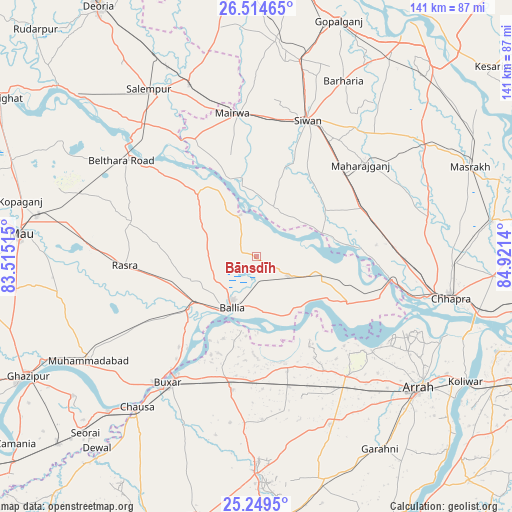
Bānsdīh GPS coordinates[2]
25° 53' 1.572" North, 84° 13' 5.772" East
| Map corner | latitude | longitude |
|---|---|---|
| Upper-left | 26.51465°, | 83.51515° |
| Center: | 25.88377°, | 84.21827° |
| Lower-right: | 25.2495°, | 84.9214° |
| Map W x H: | 140.7×140.7 km | = 87.4×87.4mi |
| max Lat: | 34.9274° ⇑30.5% North |
| Bānsdīh: | 25.88377° |
| min Lat: | ⇓69.5% South 8.09008° |
| min Long | Bānsdīh | max Long |
| 68.82655° | 84.21827° | 96.81° |
| W 82.4%⇐ | ⇒17.6% E |
Elevation
Elevation of Bānsdīh is 68 m = 223 ft, and this is 227.6 m = 747 ft below average elevation for this country.
| Max E: |
3681 m = 12077 ft | 75% |
| Avg. | 295.6 m = 970 ft | |
| Bānsdīh | 68 m = 223 ft | |
Min E: |
1 m = 3 ft | 25% |
See also: India elevation on elevation.city.
Geographical zone
Bānsdīh is located in North temperate zone (between Tropic of Cancer and the Arctic Circle). Distance of this Northern Tropic circle is 272.1 km =169.1 mi to South.| Distance of | km | miles | from Bānsdīh |
|---|---|---|---|
| North Pole | 7129.1 | 4429.8 | to North |
| Arctic Circle | 4523.2 | 2810.6 | to North |
| Tropic Cancer | 272.1 | 169.1 | to South |
| Equator | 2878 | 1788.3 | to South |


Nearby cities:
15 places around Bānsdīh: (largest is in red/bold)
• Bilthra
42.4 km =26.3 mi,  309°
309°
• Buxar
41.7 km =25.9 mi,  214°
214°
• Chāpra
54.2 km =33.7 mi,  102°
102°
• Dumraon
37.4 km =23.2 mi,  190°
190°
• Jagdīspur
50.4 km =31.3 mi,  156°
156°
• Lar
43.4 km =27 mi,  325°
325°
• Mahārājgani
38 km =23.6 mi,  48°
48°
• Mairwa
39.1 km =24.3 mi,  351°
351°
• Maniar
12.2 km =7.6 mi,  337°
337°
• Rasrā
36.5 km =22.7 mi,  265°
265°
• Reoti
16.4 km =10.2 mi, 102°
• Revelganj
43.1 km =26.8 mi, 104°
• Shāhpur
36.4 km =22.6 mi,  149°
149°
• Sikandarpur
24.2 km =15 mi,  317°
317°
• Siwān
39.9 km =24.8 mi,  20°
20°
Sources, notices
• [Note1] Compared only with cities in India existing in our database
• [Src1] Map data: © OpenStreetMap contributors (CC-BY-SA)
• [Src2] Other city data from geonames.org with taken over terms of usage.
• [Src3] Geographical zone / Annual Mean Temperature by Robert A. Rohde @ Wikipedia
