Sikandarpur geodata
Sikandarpur (Uttar Pradesh) is a populated place; located in India in Asia/Kolkata (GMT+5.5) time zone. With population of 24,177 people, there are 1757 cities with bigger population in this country. Compared to other cities in India, 70.7% of cities are located further ↓South; 82.1% of cities are located further ←West and 74.7% of cities have higher elevation than Sikandarpur. Note1


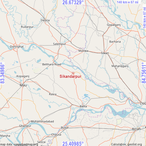
Sikandarpur GPS coordinates[2]
26° 2' 35.772" North, 84° 3' 10.728" East
| Map corner | latitude | longitude |
|---|---|---|
| Upper-left | 26.67329°, | 83.34986° |
| Center: | 26.04327°, | 84.05298° |
| Lower-right: | 25.40985°, | 84.75611° |
| Map W x H: | 140.5×140.5 km | = 87.3×87.3mi |
| max Lat: | 34.9274° ⇑29.3% North |
| Sikandarpur: | 26.04327° |
| min Lat: | ⇓70.7% South 8.09008° |
| min Long | Sikandarpur | max Long |
| 68.82655° | 84.05298° | 96.81° |
| W 82.1%⇐ | ⇒17.9% E |
Elevation
Elevation of Sikandarpur is 69 m = 226 ft, and this is 226.6 m = 743 ft below average elevation for this country.
| Max E: |
3681 m = 12077 ft | 74.7% |
| Avg. | 295.6 m = 970 ft | |
| Sikandarpur | 69 m = 226 ft | |
Min E: |
1 m = 3 ft | 25.3% |
See also: India elevation on elevation.city.
Geographical zone
Sikandarpur is located in North temperate zone (between Tropic of Cancer and the Arctic Circle). Distance of this Northern Tropic circle is 289.8 km =180.1 mi to South.| Distance of | km | miles | from Sikandarpur |
|---|---|---|---|
| North Pole | 7111.3 | 4418.8 | to North |
| Arctic Circle | 4505.4 | 2799.5 | to North |
| Tropic Cancer | 289.8 | 180.1 | to South |
| Equator | 2895.7 | 1799.3 | to South |


Nearby cities:
15 places around Sikandarpur: (largest is in red/bold)
• Bilthra
18.6 km =11.6 mi,  300°
300°
• Buxar
52.5 km =32.6 mi,  187°
187°
• Bānsdīh
24.2 km =15 mi,  137°
137°
• Dumraon
55.4 km =34.4 mi,  169°
169°
• Ghosī
51.8 km =32.2 mi,  277°
277°
• Kopāganj
48.7 km =30.3 mi,  266°
266°
• Lar
19.7 km =12.2 mi,  334°
334°
• Mahārājgani
45.6 km =28.3 mi,  80°
80°
• Mairwa
23.7 km =14.7 mi,  27°
27°
• Maniar
13.5 km =8.4 mi,  118°
118°
• Mau
50.4 km =31.3 mi,  257°
257°
• Muhammadābād
55.8 km =34.7 mi,  212°
212°
• Rasrā
28.6 km =17.8 mi,  223°
223°
• Reoti
38.9 km =24.2 mi, 123°
• Siwān
36.1 km =22.4 mi,  56°
56°
Sources, notices
• [Note1] Compared only with cities in India existing in our database
• [Src1] Map data: © OpenStreetMap contributors (CC-BY-SA)
• [Src2] Other city data from geonames.org with taken over terms of usage.
• [Src3] Geographical zone / Annual Mean Temperature by Robert A. Rohde @ Wikipedia
