Seorīnārāyan geodata
Seorīnārāyan (Chhattisgarh) is a populated place; located in India in Asia/Kolkata (GMT+5.5) time zone. With population of 8,880 people, there are 3048 cities with bigger population in this country. Compared to other cities in India, 57.9% of cities are located further ↑North; 78.2% of cities are located further ←West and 55.6% of cities have lower elevation than Seorīnārāyan. Note1


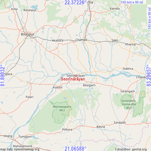
Seorīnārāyan GPS coordinates[2]
21° 43' 13.98" North, 82° 35' 36.384" East
| Map corner | latitude | longitude |
|---|---|---|
| Upper-left | 22.37226°, | 81.89032° |
| Center: | 21.72055°, | 82.59344° |
| Lower-right: | 21.06588°, | 83.29657° |
| Map W x H: | 145.3×145.3 km | = 90.3×90.3mi |
| max Lat: | 34.9274° ⇑57.9% North |
| Seorīnārāyan: | 21.72055° |
| min Lat: | ⇓42.1% South 8.09008° |
| min Long | Seorīnārāyan | max Long |
| 68.82655° | 82.59344° | 96.81° |
| W 78.2%⇐ | ⇒21.8% E |
Elevation
Elevation of Seorīnārāyan is 228 m = 748 ft, and this is 67.6 m = 222 ft below average elevation for this country.
| Max E: |
3681 m = 12077 ft | 44.4% |
| Avg. | 295.6 m = 970 ft | |
| Seorīnārāyan | 228 m = 748 ft | |
Min E: |
1 m = 3 ft | 55.6% |
See also: India elevation on elevation.city.
Geographical zone
Seorīnārāyan is located in North Torrid zone (between Equator and Tropic of Cancer). Distance of this Northern Tropic circle is 190.8 km =118.6 mi to North.| Distance of | km | miles | from Seorīnārāyan |
|---|---|---|---|
| North Pole | 7592 | 4717.4 | to North |
| Arctic Circle | 4986.1 | 3098.2 | to North |
| Tropic Cancer | 190.8 | 118.6 | to North |
| Equator | 2415.1 | 1500.7 | to South |


Nearby cities:
15 places around Seorīnārāyan: (largest is in red/bold)
• Akaltara
37.9 km =23.5 mi,  332°
332°
• Baloda
47.9 km =29.8 mi,  346°
346°
• Baloda Bāzār
45.3 km =28.1 mi,  260°
260°
• Basna
54.7 km =34 mi,  153°
153°
• Bhātāpāra
66.8 km =41.5 mi,  271°
271°
• Bilāspur
60.3 km =37.5 mi,  311°
311°
• Chāmpa
35.4 km =22 mi,  8°
8°
• Deori
30.2 km =18.8 mi,  175°
175°
• Jānjgīr
32.1 km =19.9 mi,  357°
357°
• Kharod
3 km =1.9 mi, 330°
• Kharsia
60.7 km =37.7 mi,  60°
60°
• Pithora
52.9 km =32.9 mi,  188°
188°
• Saktī
50.9 km =31.6 mi,  48°
48°
• Saraipali
62.1 km =38.6 mi,  136°
136°
• Sārangarh
52.3 km =32.5 mi,  106°
106°
Sources, notices
• [Note1] Compared only with cities in India existing in our database
• [Src1] Map data: © OpenStreetMap contributors (CC-BY-SA)
• [Src2] Other city data from geonames.org with taken over terms of usage.
• [Src3] Geographical zone / Annual Mean Temperature by Robert A. Rohde @ Wikipedia
