Kharod geodata
Kharod (Chhattisgarh) is a populated place; located in India in Asia/Kolkata (GMT+5.5) time zone. With population of 8,926 people, there are 3040 cities with bigger population in this country. Compared to other cities in India, 57.7% of cities are located further ↑North; 78.2% of cities are located further ←West and 58.9% of cities have lower elevation than Kharod. Note1


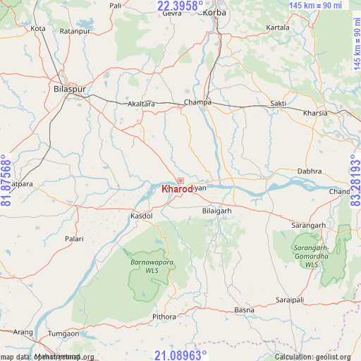
Kharod GPS coordinates[2]
21° 44' 39.12" North, 82° 34' 43.68" East
| Map corner | latitude | longitude |
|---|---|---|
| Upper-left | 22.3958°, | 81.87568° |
| Center: | 21.7442°, | 82.5788° |
| Lower-right: | 21.08963°, | 83.28193° |
| Map W x H: | 145.2×145.2 km | = 90.2×90.2mi |
| max Lat: | 34.9274° ⇑57.7% North |
| Kharod: | 21.7442° |
| min Lat: | ⇓42.3% South 8.09008° |
| min Long | Kharod | max Long |
| 68.82655° | 82.5788° | 96.81° |
| W 78.2%⇐ | ⇒21.8% E |
Elevation
Elevation of Kharod is 244 m = 801 ft, and this is 51.6 m = 169 ft below average elevation for this country.
| Max E: |
3681 m = 12077 ft | 41.1% |
| Avg. | 295.6 m = 970 ft | |
| Kharod | 244 m = 801 ft | |
Min E: |
1 m = 3 ft | 58.9% |
See also: India elevation on elevation.city.
Geographical zone
Kharod is located in North Torrid zone (between Equator and Tropic of Cancer). Distance of this Northern Tropic circle is 188.2 km =116.9 mi to North.| Distance of | km | miles | from Kharod |
|---|---|---|---|
| North Pole | 7589.3 | 4715.8 | to North |
| Arctic Circle | 4983.4 | 3096.5 | to North |
| Tropic Cancer | 188.2 | 116.9 | to North |
| Equator | 2417.7 | 1502.3 | to South |


Nearby cities:
15 places around Kharod: (largest is in red/bold)
• Akaltara
34.9 km =21.7 mi,  333°
333°
• Baloda
45 km =28 mi,  347°
347°
• Baloda Bāzār
44.3 km =27.5 mi,  257°
257°
• Basna
57.7 km =35.9 mi,  153°
153°
• Bhātāpāra
65.2 km =40.5 mi,  269°
269°
• Bilāspur
57.5 km =35.7 mi,  310°
310°
• Chāmpa
33 km =20.5 mi,  11°
11°
• Deori
32.9 km =20.4 mi,  173°
173°
• Jānjgīr
29.5 km =18.3 mi,  359°
359°
• Kharsia
60.7 km =37.7 mi,  63°
63°
• Pithora
55.3 km =34.4 mi,  186°
186°
• Saktī
50.4 km =31.3 mi,  51°
51°
• Saraipali
65 km =40.4 mi,  137°
137°
• Seorīnārāyan
3 km =1.9 mi, 150°
• Sārangarh
54.5 km =33.9 mi,  108°
108°
Sources, notices
• [Note1] Compared only with cities in India existing in our database
• [Src1] Map data: © OpenStreetMap contributors (CC-BY-SA)
• [Src2] Other city data from geonames.org with taken over terms of usage.
• [Src3] Geographical zone / Annual Mean Temperature by Robert A. Rohde @ Wikipedia
