Betūl geodata
Betūl (Madhya Pradesh) is a populated place; located in India in Asia/Kolkata (GMT+5.5) time zone. With population of 91,953 people, there are 485 cities with bigger population in this country. Compared to other cities in India, 57% of cities are located further ↑North; 52.3% of cities are located further →East and 90.5% of cities have lower elevation than Betūl. Note1


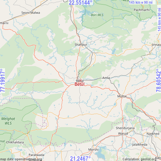
Betūl GPS coordinates[2]
21° 54' 2.016" North, 77° 54' 8.244" East
| Map corner | latitude | longitude |
|---|---|---|
| Upper-left | 22.55144°, | 77.19917° |
| Center: | 21.90056°, | 77.90229° |
| Lower-right: | 21.2467°, | 78.60542° |
| Map W x H: | 145.1×145.1 km | = 90.2×90.2mi |
| max Lat: | 34.9274° ⇑57% North |
| Betūl: | 21.90056° |
| min Lat: | ⇓43% South 8.09008° |
| min Long | Betūl | max Long |
| 68.82655° | 77.90229° | 96.81° |
| W 47.7%⇐ | ⇒52.3% E |
Elevation
Elevation of Betūl is 645 m = 2116 ft, and this is 349.4 m = 1146 ft above average elevation for this country.
| Max E: |
3681 m = 12077 ft | 9.5% |
| Betūl | 645 m 2116 ft | |
| Avg. | 295.6 m = 970 ft | |
Min E: |
1 m = 3 ft | 90.5% |
See also: Betūl elevation on elevation.city.
Geographical zone
Betūl is located in North Torrid zone (between Equator and Tropic of Cancer). Distance of this Northern Tropic circle is 170.8 km =106.1 mi to North.| Distance of | km | miles | from Betūl |
|---|---|---|---|
| North Pole | 7571.9 | 4705 | to North |
| Arctic Circle | 4966.1 | 3085.8 | to North |
| Tropic Cancer | 170.8 | 106.1 | to North |
| Equator | 2435.1 | 1513.1 | to South |


Nearby cities:
15 places around Betūl: (largest is in red/bold)
• Achalpur
82.3 km =51.1 mi,  209°
209°
• Amla
23.4 km =14.5 mi,  83°
83°
• Betūl Bazār
5.7 km =3.5 mi,  150°
150°
• Bhainsdehi
40 km =24.9 mi,  224°
224°
• Chāndūr Bāzār
75.3 km =46.8 mi,  192°
192°
• Itārsi
80.7 km =50.1 mi,  349°
349°
• Jāmai
78.3 km =48.7 mi,  65°
65°
• Morsi
63.3 km =39.3 mi,  169°
169°
• Mowād
74.6 km =46.4 mi,  130°
130°
• Multai
39.3 km =24.4 mi,  110°
110°
• Panara
75 km =46.6 mi,  63°
63°
• Pāndhurnā
72.8 km =45.2 mi,  117°
117°
• Seoni Mālwa
75.8 km =47.1 mi,  323°
323°
• Shāhpur
32.8 km =20.4 mi,  0°
0°
• Warud
61 km =37.9 mi,  141°
141°
Sources, notices
• [Note1] Compared only with cities in India existing in our database
• [Src1] Map data: © OpenStreetMap contributors (CC-BY-SA)
• [Src2] Other city data from geonames.org with taken over terms of usage.
• [Src3] Geographical zone / Annual Mean Temperature by Robert A. Rohde @ Wikipedia
