Shāhpur geodata
Shāhpur (Madhya Pradesh) is a populated place; located in India in Asia/Kolkata (GMT+5.5) time zone. With population of 4,302 people, there are 3367 cities with bigger population in this country. Compared to other cities in India, 55.3% of cities are located further ↑North; 52.3% of cities are located further →East and 75.5% of cities have lower elevation than Shāhpur. Note1


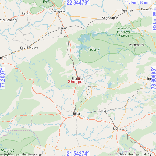
Shāhpur GPS coordinates[2]
22° 11' 42.936" North, 77° 54' 24.552" East
| Map corner | latitude | longitude |
|---|---|---|
| Upper-left | 22.84476°, | 77.2037° |
| Center: | 22.19526°, | 77.90682° |
| Lower-right: | 21.54274°, | 78.60995° |
| Map W x H: | 144.8×144.8 km | = 90×90mi |
| max Lat: | 34.9274° ⇑55.3% North |
| Shāhpur: | 22.19526° |
| min Lat: | ⇓44.7% South 8.09008° |
| min Long | Shāhpur | max Long |
| 68.82655° | 77.90682° | 96.81° |
| W 47.7%⇐ | ⇒52.3% E |
Elevation
Elevation of Shāhpur is 393 m = 1289 ft, and this is 97.4 m = 320 ft above average elevation for this country.
| Max E: |
3681 m = 12077 ft | 24.5% |
| Shāhpur | 393 m 1289 ft | |
| Avg. | 295.6 m = 970 ft | |
Min E: |
1 m = 3 ft | 75.5% |
See also: India elevation on elevation.city.
Geographical zone
Shāhpur is located in North Torrid zone (between Equator and Tropic of Cancer). Distance of this Northern Tropic circle is 138 km =85.7 mi to North.| Distance of | km | miles | from Shāhpur |
|---|---|---|---|
| North Pole | 7539.2 | 4684.6 | to North |
| Arctic Circle | 4933.3 | 3065.4 | to North |
| Tropic Cancer | 138 | 85.7 | to North |
| Equator | 2467.9 | 1533.5 | to South |


Nearby cities:
15 places around Shāhpur: (largest is in red/bold)
• Amla
37.7 km =23.4 mi,  142°
142°
• Betūl
32.8 km =20.4 mi,  180°
180°
• Betūl Bazār
37.8 km =23.5 mi, 176°
• Bhainsdehi
67.5 km =41.9 mi,  204°
204°
• Bābai
56.5 km =35.1 mi,  2°
2°
• Hoshangābād
64.1 km =39.8 mi,  343°
343°
• Itārsi
49 km =30.4 mi, 342°
• Jāmai
70.5 km =43.8 mi,  89°
89°
• Multai
59.1 km =36.7 mi, 142°
• Nasrullāhganj
85 km =52.8 mi,  309°
309°
• Pachmarhi
62 km =38.5 mi,  60°
60°
• Panara
66.3 km =41.2 mi, 88°
• Rehti
77.5 km =48.2 mi,  321°
321°
• Seoni Mālwa
53.4 km =33.2 mi,  302°
302°
• Sohāgpur
63.5 km =39.5 mi,  27°
27°
Sources, notices
• [Note1] Compared only with cities in India existing in our database
• [Src1] Map data: © OpenStreetMap contributors (CC-BY-SA)
• [Src2] Other city data from geonames.org with taken over terms of usage.
• [Src3] Geographical zone / Annual Mean Temperature by Robert A. Rohde @ Wikipedia
