Panara geodata
Panara (Madhya Pradesh) is a populated place; located in India in Asia/Kolkata (GMT+5.5) time zone. With population of 4,096 people, there are 3375 cities with bigger population in this country. Compared to other cities in India, 55.2% of cities are located further ↑North; 54.7% of cities are located further ←West and 93.9% of cities have lower elevation than Panara. Note1


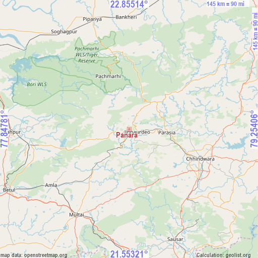
Panara GPS coordinates[2]
22° 12' 20.448" North, 78° 33' 3.348" East
| Map corner | latitude | longitude |
|---|---|---|
| Upper-left | 22.85514°, | 77.84781° |
| Center: | 22.20568°, | 78.55093° |
| Lower-right: | 21.55321°, | 79.25406° |
| Map W x H: | 144.8×144.8 km | = 90×90mi |
| max Lat: | 34.9274° ⇑55.2% North |
| Panara: | 22.20568° |
| min Lat: | ⇓44.8% South 8.09008° |
| min Long | Panara | max Long |
| 68.82655° | 78.55093° | 96.81° |
| W 54.7%⇐ | ⇒45.3% E |
Elevation
Elevation of Panara is 791 m = 2595 ft, and this is 495.4 m = 1625 ft above average elevation for this country.
| Max E: |
3681 m = 12077 ft | 6.1% |
| Panara | 791 m 2595 ft | |
| Avg. | 295.6 m = 970 ft | |
Min E: |
1 m = 3 ft | 93.9% |
See also: India elevation on elevation.city.
Geographical zone
Panara is located in North Torrid zone (between Equator and Tropic of Cancer). Distance of this Northern Tropic circle is 136.9 km =85.1 mi to North.| Distance of | km | miles | from Panara |
|---|---|---|---|
| North Pole | 7538 | 4683.9 | to North |
| Arctic Circle | 4932.1 | 3064.7 | to North |
| Tropic Cancer | 136.9 | 85.1 | to North |
| Equator | 2469 | 1534.2 | to South |


Nearby cities:
15 places around Panara: (largest is in red/bold)
• Amarwāra
64.5 km =40.1 mi,  80°
80°
• Amla
53.6 km =33.3 mi,  234°
234°
• Betūl
75 km =46.6 mi,  243°
243°
• Betūl Bazār
75 km =46.6 mi, 238°
• Chhindwāra
43.3 km =26.9 mi,  112°
112°
• Chichli
75.3 km =46.8 mi,  22°
22°
• Jāmai
4.3 km =2.7 mi,  103°
103°
• Mohgaon
65.8 km =40.9 mi,  163°
163°
• Multai
56.7 km =35.2 mi,  212°
212°
• Pachmarhi
31.6 km =19.6 mi,  337°
337°
• Parāsia
21.5 km =13.4 mi,  94°
94°
• Pāndhurnā
67.9 km =42.2 mi,  182°
182°
• Sausar
66.2 km =41.1 mi, 157°
• Shāhpur
66.3 km =41.2 mi,  268°
268°
• Sohāgpur
66.1 km =41.1 mi,  326°
326°
Sources, notices
• [Note1] Compared only with cities in India existing in our database
• [Src1] Map data: © OpenStreetMap contributors (CC-BY-SA)
• [Src2] Other city data from geonames.org with taken over terms of usage.
• [Src3] Geographical zone / Annual Mean Temperature by Robert A. Rohde @ Wikipedia
