Itārsi geodata
Itārsi (Madhya Pradesh) is a populated place; located in India in Asia/Kolkata (GMT+5.5) time zone. With population of 100,574 people, there are 437 cities with bigger population in this country. Compared to other cities in India, 51.9% of cities are located further ↑North; 54.2% of cities are located further →East and 69.7% of cities have lower elevation than Itārsi. Note1


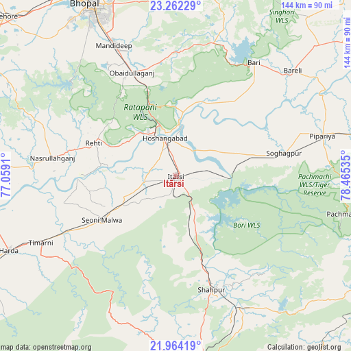
Itārsi GPS coordinates[2]
22° 36' 53.172" North, 77° 45' 43.992" East
| Map corner | latitude | longitude |
|---|---|---|
| Upper-left | 23.26229°, | 77.0591° |
| Center: | 22.61477°, | 77.76222° |
| Lower-right: | 21.96419°, | 78.46535° |
| Map W x H: | 144.3×144.3 km | = 89.7×89.7mi |
| max Lat: | 34.9274° ⇑51.9% North |
| Itārsi: | 22.61477° |
| min Lat: | ⇓48.1% South 8.09008° |
| min Long | Itārsi | max Long |
| 68.82655° | 77.76222° | 96.81° |
| W 45.8%⇐ | ⇒54.2% E |
Elevation
Elevation of Itārsi is 325 m = 1066 ft, and this is 29.4 m = 96 ft above average elevation for this country.
| Max E: |
3681 m = 12077 ft | 30.3% |
| Itārsi | 325 m 1066 ft | |
| Avg. | 295.6 m = 970 ft | |
Min E: |
1 m = 3 ft | 69.7% |
See also: Itārsi elevation on elevation.city.
Geographical zone
Itārsi is located in North Torrid zone (between Equator and Tropic of Cancer). Distance of this Northern Tropic circle is 91.4 km =56.8 mi to North.| Distance of | km | miles | from Itārsi |
|---|---|---|---|
| North Pole | 7492.5 | 4655.6 | to North |
| Arctic Circle | 4886.6 | 3036.4 | to North |
| Tropic Cancer | 91.4 | 56.8 | to North |
| Equator | 2514.5 | 1562.4 | to South |


Nearby cities:
15 places around Itārsi: (largest is in red/bold)
• Amla
85.4 km =53.1 mi,  153°
153°
• Betūl
80.7 km =50.1 mi,  169°
169°
• Bhopal
80.1 km =49.8 mi,  332°
332°
• Bābai
20.2 km =12.6 mi,  61°
61°
• Harda Khās
74.8 km =46.5 mi,  246°
246°
• Hoshangābād
15.2 km =9.4 mi,  346°
346°
• Mandideep
57 km =35.4 mi,  335°
335°
• Nasrullāhganj
51 km =31.7 mi,  278°
278°
• Pachmarhi
70.8 km =44 mi,  103°
103°
• Raisen
79.6 km =49.5 mi,  1°
1°
• Rehti
36.3 km =22.6 mi,  292°
292°
• Seoni Mālwa
35.4 km =22 mi,  238°
238°
• Shāhpur
49 km =30.4 mi,  162°
162°
• Sohāgpur
45.4 km =28.2 mi,  77°
77°
• Sultānpur
60.8 km =37.8 mi,  16°
16°
Sources, notices
• [Note1] Compared only with cities in India existing in our database
• [Src1] Map data: © OpenStreetMap contributors (CC-BY-SA)
• [Src2] Other city data from geonames.org with taken over terms of usage.
• [Src3] Geographical zone / Annual Mean Temperature by Robert A. Rohde @ Wikipedia
