Barkhera Kalān geodata
Barkhera Kalān (Uttar Pradesh) is a populated place; located in India in Asia/Kolkata (GMT+5.5) time zone. With population of 11,209 people, there are 2813 cities with bigger population in this country. Compared to other cities in India, 86.6% of cities are located further ↓South; 66.5% of cities are located further ←West and 53.8% of cities have higher elevation than Barkhera Kalān. Note1


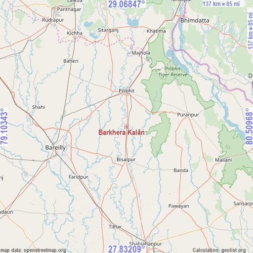
Barkhera Kalān GPS coordinates[2]
28° 27' 7.524" North, 79° 48' 23.58" East
| Map corner | latitude | longitude |
|---|---|---|
| Upper-left | 29.06847°, | 79.10343° |
| Center: | 28.45209°, | 79.80655° |
| Lower-right: | 27.83209°, | 80.50968° |
| Map W x H: | 137.5×137.5 km | = 85.4×85.4mi |
| max Lat: | 34.9274° ⇑13.4% North |
| Barkhera Kalān: | 28.45209° |
| min Lat: | ⇓86.6% South 8.09008° |
| min Long | Barkhera Kalān | max Long |
| 68.82655° | 79.80655° | 96.81° |
| W 66.5%⇐ | ⇒33.5% E |
Elevation
Elevation of Barkhera Kalān is 181 m = 594 ft, and this is 114.6 m = 376 ft below average elevation for this country.
| Max E: |
3681 m = 12077 ft | 53.8% |
| Avg. | 295.6 m = 970 ft | |
| Barkhera Kalān | 181 m = 594 ft | |
Min E: |
1 m = 3 ft | 46.2% |
See also: India elevation on elevation.city.
Geographical zone
Barkhera Kalān is located in North temperate zone (between Tropic of Cancer and the Arctic Circle). Distance of this Northern Tropic circle is 557.7 km =346.5 mi to South.| Distance of | km | miles | from Barkhera Kalān |
|---|---|---|---|
| North Pole | 6843.5 | 4252.4 | to North |
| Arctic Circle | 4237.6 | 2633.1 | to North |
| Tropic Cancer | 557.7 | 346.5 | to South |
| Equator | 3163.6 | 1965.8 | to South |


Nearby cities:
15 places around Barkhera Kalān: (largest is in red/bold)
• Baheri
46.8 km =29.1 mi,  319°
319°
• Bareilly
37.9 km =23.5 mi,  255°
255°
• Bilsanda
27.2 km =16.9 mi,  148°
148°
• Bīsalpur
17.7 km =11 mi,  180°
180°
• Deoraniān
37.8 km =23.5 mi,  301°
301°
• Farīdpur
37.4 km =23.2 mi,  223°
223°
• Jahānābād
21.6 km =13.4 mi,  336°
336°
• Khudāganj
35.2 km =21.9 mi,  194°
194°
• Kālīnagar
32.7 km =20.3 mi,  55°
55°
• Mohanpur
48.3 km =30 mi,  117°
117°
• Nawābganj
19.5 km =12.1 mi, 300°
• Pīlibhīt
19.9 km =12.4 mi,  359°
359°
• Pūranpur
34.1 km =21.2 mi,  78°
78°
• Richha
38.7 km =24 mi,  314°
314°
• Shergarh
48.2 km =30 mi, 297°
Sources, notices
• [Note1] Compared only with cities in India existing in our database
• [Src1] Map data: © OpenStreetMap contributors (CC-BY-SA)
• [Src2] Other city data from geonames.org with taken over terms of usage.
• [Src3] Geographical zone / Annual Mean Temperature by Robert A. Rohde @ Wikipedia
