Bālurghāt geodata
Bālurghāt (West Bengal) is a populated place; located in India in Asia/Kolkata (GMT+5.5) time zone. With population of 141,404 people, there are 304 cities with bigger population in this country. Compared to other cities in India, 64.7% of cities are located further ↓South; 94.9% of cities are located further ←West and 85.5% of cities have higher elevation than Bālurghāt. Note1


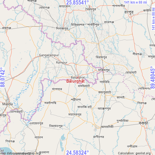
Bālurghāt GPS coordinates[2]
25° 13' 15.564" North, 88° 46' 38.352" East
| Map corner | latitude | longitude |
|---|---|---|
| Upper-left | 25.85541°, | 88.0742° |
| Center: | 25.22099°, | 88.77732° |
| Lower-right: | 24.58324°, | 89.48045° |
| Map W x H: | 141.5×141.5 km | = 87.9×87.9mi |
| max Lat: | 34.9274° ⇑35.3% North |
| Bālurghāt: | 25.22099° |
| min Lat: | ⇓64.7% South 8.09008° |
| min Long | Bālurghāt | max Long |
| 68.82655° | 88.77732° | 96.81° |
| W 94.9%⇐ | ⇒5.1% E |
Elevation
Elevation of Bālurghāt is 29 m = 95 ft, and this is 266.6 m = 875 ft below average elevation for this country.
| Max E: |
3681 m = 12077 ft | 85.5% |
| Avg. | 295.6 m = 970 ft | |
| Bālurghāt | 29 m = 95 ft | |
Min E: |
1 m = 3 ft | 14.5% |
See also: Bālurghāt elevation on elevation.city.
Geographical zone
Bālurghāt is located in North temperate zone (between Tropic of Cancer and the Arctic Circle). Distance of this Northern Tropic circle is 198.4 km =123.3 mi to South.| Distance of | km | miles | from Bālurghāt |
|---|---|---|---|
| North Pole | 7202.8 | 4475.6 | to North |
| Arctic Circle | 4596.9 | 2856.4 | to North |
| Tropic Cancer | 198.4 | 123.3 | to South |
| Equator | 2804.3 | 1742.5 | to South |


Nearby cities:
15 places around Bālurghāt: (largest is in red/bold)
• Daulatpur
46.5 km =28.9 mi,  284°
284°
• Debīpur
109.1 km =67.8 mi,  188°
188°
• Dhuliān
102.5 km =63.7 mi,  234°
234°
• Farakka
99.2 km =61.6 mi,  243°
243°
• Gangārāmpur
32 km =19.9 mi,  308°
308°
• Ingrāj Bāzār
68 km =42.3 mi,  249°
249°
• Jangipur
109.4 km =68 mi,  220°
220°
• Kāliyāganj
64.5 km =40.1 mi,  315°
315°
• Lālgola
103.4 km =64.2 mi,  210°
210°
• Mankāchar
114.5 km =71.1 mi,  72°
72°
• Paikpara
99.6 km =61.9 mi, 239°
• Pakur
114.3 km =71 mi, 235°
• Raghunāthpur
98.4 km =61.1 mi,  298°
298°
• Rāiganj
78.7 km =48.9 mi, 303°
• Rājmahal
97.1 km =60.3 mi,  258°
258°
Sources, notices
• [Note1] Compared only with cities in India existing in our database
• [Src1] Map data: © OpenStreetMap contributors (CC-BY-SA)
• [Src2] Other city data from geonames.org with taken over terms of usage.
• [Src3] Geographical zone / Annual Mean Temperature by Robert A. Rohde @ Wikipedia
