Gangārāmpur geodata
Gangārāmpur (West Bengal) is a populated place; located in India in Asia/Kolkata (GMT+5.5) time zone. With population of 65,316 people, there are 669 cities with bigger population in this country. Compared to other cities in India, 66% of cities are located further ↓South; 94.4% of cities are located further ←West and 84.4% of cities have higher elevation than Gangārāmpur. Note1


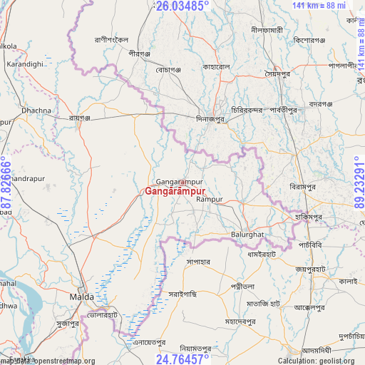
Gangārāmpur GPS coordinates[2]
25° 24' 4.968" North, 88° 31' 47.208" East
| Map corner | latitude | longitude |
|---|---|---|
| Upper-left | 26.03485°, | 87.82666° |
| Center: | 25.40138°, | 88.52978° |
| Lower-right: | 24.76457°, | 89.23291° |
| Map W x H: | 141.2×141.2 km | = 87.7×87.7mi |
| max Lat: | 34.9274° ⇑34% North |
| Gangārāmpur: | 25.40138° |
| min Lat: | ⇓66% South 8.09008° |
| min Long | Gangārāmpur | max Long |
| 68.82655° | 88.52978° | 96.81° |
| W 94.4%⇐ | ⇒5.6% E |
Elevation
Elevation of Gangārāmpur is 32 m = 105 ft, and this is 263.6 m = 865 ft below average elevation for this country.
| Max E: |
3681 m = 12077 ft | 84.4% |
| Avg. | 295.6 m = 970 ft | |
| Gangārāmpur | 32 m = 105 ft | |
Min E: |
1 m = 3 ft | 15.6% |
See also: Gangārāmpur elevation on elevation.city.
Geographical zone
Gangārāmpur is located in North temperate zone (between Tropic of Cancer and the Arctic Circle). Distance of this Northern Tropic circle is 218.4 km =135.7 mi to South.| Distance of | km | miles | from Gangārāmpur |
|---|---|---|---|
| North Pole | 7182.7 | 4463.1 | to North |
| Arctic Circle | 4576.8 | 2843.9 | to North |
| Tropic Cancer | 218.4 | 135.7 | to South |
| Equator | 2824.4 | 1755 | to South |


Nearby cities:
15 places around Gangārāmpur: (largest is in red/bold)
• Baisi
93.9 km =58.3 mi,  303°
303°
• Bālurghāt
32 km =19.9 mi,  128°
128°
• Dalkola
87 km =54.1 mi,  307°
307°
• Daulatpur
21.8 km =13.5 mi,  247°
247°
• Farakka
90.8 km =56.4 mi,  224°
224°
• Ingrāj Bāzār
58.7 km =36.5 mi, 221°
• Katihar
97.5 km =60.6 mi,  278°
278°
• Kishanganj
96.9 km =60.2 mi,  323°
323°
• Kāliyāganj
33 km =20.5 mi, 321°
• Manihāri
91.7 km =57 mi,  265°
265°
• Paikpara
93 km =57.8 mi, 221°
• Raghunāthpur
67.1 km =41.7 mi,  293°
293°
• Rāiganj
47 km =29.2 mi, 300°
• Rājmahal
80.3 km =49.9 mi,  241°
241°
• Sāhibganj
91.6 km =56.9 mi,  259°
259°
Sources, notices
• [Note1] Compared only with cities in India existing in our database
• [Src1] Map data: © OpenStreetMap contributors (CC-BY-SA)
• [Src2] Other city data from geonames.org with taken over terms of usage.
• [Src3] Geographical zone / Annual Mean Temperature by Robert A. Rohde @ Wikipedia
