Rāiganj geodata
Rāiganj (West Bengal) is a populated place; located in India in Asia/Kolkata (GMT+5.5) time zone. With population of 170,252 people, there are 254 cities with bigger population in this country. Compared to other cities in India, 67.7% of cities are located further ↓South; 91.4% of cities are located further ←West and 82.6% of cities have higher elevation than Rāiganj. Note1


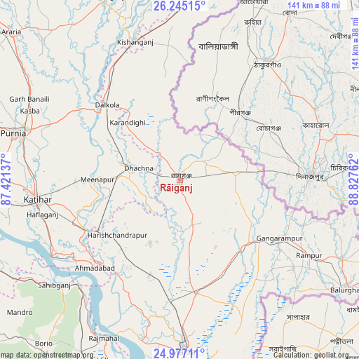
Rāiganj GPS coordinates[2]
25° 36' 46.116" North, 88° 7' 28.164" East
| Map corner | latitude | longitude |
|---|---|---|
| Upper-left | 26.24515°, | 87.42137° |
| Center: | 25.61281°, | 88.12449° |
| Lower-right: | 24.97711°, | 88.82762° |
| Map W x H: | 141×141 km | = 87.6×87.6mi |
| max Lat: | 34.9274° ⇑32.3% North |
| Rāiganj: | 25.61281° |
| min Lat: | ⇓67.7% South 8.09008° |
| min Long | Rāiganj | max Long |
| 68.82655° | 88.12449° | 96.81° |
| W 91.4%⇐ | ⇒8.6% E |
Elevation
Elevation of Rāiganj is 38 m = 125 ft, and this is 257.6 m = 845 ft below average elevation for this country.
| Max E: |
3681 m = 12077 ft | 82.6% |
| Avg. | 295.6 m = 970 ft | |
| Rāiganj | 38 m = 125 ft | |
Min E: |
1 m = 3 ft | 17.4% |
See also: Rāiganj elevation on elevation.city.
Geographical zone
Rāiganj is located in North temperate zone (between Tropic of Cancer and the Arctic Circle). Distance of this Northern Tropic circle is 242 km =150.4 mi to South.| Distance of | km | miles | from Rāiganj |
|---|---|---|---|
| North Pole | 7159.2 | 4448.5 | to North |
| Arctic Circle | 4553.3 | 2829.3 | to North |
| Tropic Cancer | 242 | 150.4 | to South |
| Equator | 2847.9 | 1769.6 | to South |


Nearby cities:
15 places around Rāiganj: (largest is in red/bold)
• Baisi
47.1 km =29.3 mi,  306°
306°
• Dalkola
40.8 km =25.4 mi,  315°
315°
• Daulatpur
38 km =23.6 mi,  147°
147°
• Gangārāmpur
47 km =29.2 mi,  120°
120°
• Ingrāj Bāzār
67.7 km =42.1 mi,  178°
178°
• Islāmpur
72.9 km =45.3 mi,  5°
5°
• Kasba
64.7 km =40.2 mi,  294°
294°
• Katihar
56.2 km =34.9 mi,  261°
261°
• Kishanganj
57 km =35.4 mi,  342°
342°
• Kāliyāganj
20.4 km =12.7 mi,  83°
83°
• Manihāri
59.1 km =36.7 mi,  238°
238°
• Purnia
67.7 km =42.1 mi, 285°
• Raghunāthpur
21 km =13 mi,  279°
279°
• Rājmahal
68.9 km =42.8 mi,  205°
205°
• Sāhibganj
64 km =39.8 mi,  230°
230°
Sources, notices
• [Note1] Compared only with cities in India existing in our database
• [Src1] Map data: © OpenStreetMap contributors (CC-BY-SA)
• [Src2] Other city data from geonames.org with taken over terms of usage.
• [Src3] Geographical zone / Annual Mean Temperature by Robert A. Rohde @ Wikipedia
