Sulur geodata
Sulur (Tamil Nadu) is a populated place; located in India in Asia/Kolkata (GMT+5.5) time zone. With population of 26,183 people, there are 1629 cities with bigger population in this country. Compared to other cities in India, 93% of cities are located further ↑North; 61.7% of cities are located further →East and 74.2% of cities have lower elevation than Sulur. Note1


Sulur GPS coordinates[2]
11° 1' 27.372" North, 77° 7' 32.34" East
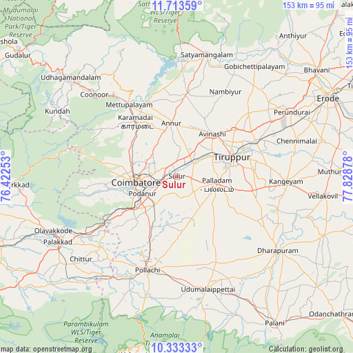
| Map corner | latitude | longitude |
|---|---|---|
| Upper-left | 11.71359°, | 76.42253° |
| Center: | 11.02427°, | 77.12565° |
| Lower-right: | 10.33333°, | 77.82878° |
| Map W x H: | 153.5×153.5 km | = 95.4×95.4mi |
| max Lat: | 34.9274° ⇑93% North |
| Sulur: | 11.02427° |
| min Lat: | ⇓7% South 8.09008° |
| min Long | Sulur | max Long |
| 68.82655° | 77.12565° | 96.81° |
| W 38.3%⇐ | ⇒61.7% E |
Elevation
Elevation of Sulur is 376 m = 1234 ft, and this is 80.4 m = 264 ft above average elevation for this country.
| Max E: |
3681 m = 12077 ft | 25.8% |
| Sulur | 376 m 1234 ft | |
| Avg. | 295.6 m = 970 ft | |
Min E: |
1 m = 3 ft | 74.2% |
See also: India elevation on elevation.city.
Geographical zone
Sulur is located in North Torrid zone (between Equator and Tropic of Cancer). Distance of Equator is 1225.8 km =761.7 mi to South.| Distance of | km | miles | from Sulur |
|---|---|---|---|
| North Pole | 8781.3 | 5456.4 | to North |
| Arctic Circle | 6175.4 | 3837.2 | to North |
| Tropic Cancer | 1380.1 | 857.6 | to North |
| Equator | 1225.8 | 761.7 | to South |


Nearby cities:
15 places around Sulur: (largest is in red/bold)
• Annur
23.7 km =14.7 mi,  354°
354°
• Avinashi
24.4 km =15.2 mi,  39°
39°
• Chettipālaiyam
15.8 km =9.8 mi,  217°
217°
• Coimbatore
17.5 km =10.9 mi,  263°
263°
• Irugūr
6.9 km =4.3 mi, 264°
• Kāramadai
30.1 km =18.7 mi,  323°
323°
• Madukkarai
22.1 km =13.7 mi,  233°
233°
• Palladam
17.9 km =11.1 mi,  101°
101°
• Periyanayakkanpalaiyam
23.8 km =14.8 mi,  306°
306°
• Periyanegamam
31.4 km =19.5 mi,  184°
184°
• Periyapatti
33.6 km =20.9 mi,  151°
151°
• Perūr
23.9 km =14.9 mi, 256°
• Singānallūr
10.6 km =6.6 mi,  254°
254°
• Sirumugai
35.6 km =22.1 mi,  338°
338°
• Tiruppur
27 km =16.8 mi,  67°
67°
Sources, notices
• [Note1] Compared only with cities in India existing in our database
• [Src1] Map data: © OpenStreetMap contributors (CC-BY-SA)
• [Src2] Other city data from geonames.org with taken over terms of usage.
• [Src3] Geographical zone / Annual Mean Temperature by Robert A. Rohde @ Wikipedia
