Kaintragarh geodata
Kaintragarh (Odisha) is a populated place; located in India in Asia/Kolkata (GMT+5.5) time zone. With population of 11,918 people, there are 2748 cities with bigger population in this country. Compared to other cities in India, 63% of cities are located further ↑North; 83.2% of cities are located further ←West and 70.2% of cities have higher elevation than Kaintragarh. Note1


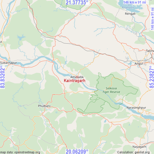
Kaintragarh GPS coordinates[2]
20° 43' 16.14" North, 84° 32' 6.504" East
| Map corner | latitude | longitude |
|---|---|---|
| Upper-left | 21.37735°, | 83.83202° |
| Center: | 20.72115°, | 84.53514° |
| Lower-right: | 20.06209°, | 85.23827° |
| Map W x H: | 146.2×146.2 km | = 90.8×90.8mi |
| max Lat: | 34.9274° ⇑63% North |
| Kaintragarh: | 20.72115° |
| min Lat: | ⇓37% South 8.09008° |
| min Long | Kaintragarh | max Long |
| 68.82655° | 84.53514° | 96.81° |
| W 83.2%⇐ | ⇒16.8% E |
Elevation
Elevation of Kaintragarh is 91 m = 299 ft, and this is 204.6 m = 671 ft below average elevation for this country.
| Max E: |
3681 m = 12077 ft | 70.2% |
| Avg. | 295.6 m = 970 ft | |
| Kaintragarh | 91 m = 299 ft | |
Min E: |
1 m = 3 ft | 29.8% |
See also: India elevation on elevation.city.
Geographical zone
Kaintragarh is located in North Torrid zone (between Equator and Tropic of Cancer). Distance of this Northern Tropic circle is 301.9 km =187.6 mi to North.| Distance of | km | miles | from Kaintragarh |
|---|---|---|---|
| North Pole | 7703.1 | 4786.5 | to North |
| Arctic Circle | 5097.2 | 3167.3 | to North |
| Tropic Cancer | 301.9 | 187.6 | to North |
| Equator | 2304 | 1431.6 | to South |


Nearby cities:
15 places around Kaintragarh: (largest is in red/bold)
• Angul
60.4 km =37.5 mi,  77°
77°
• Baud
25.3 km =15.7 mi,  300°
300°
• Belaguntha
93.9 km =58.3 mi,  173°
173°
• Bhanjanagar
88.4 km =54.9 mi,  176°
176°
• Binka
82.4 km =51.2 mi,  294°
294°
• Bālugaon
85.3 km =53 mi,  135°
135°
• Deogarh
93.2 km =57.9 mi,  12°
12°
• Kantilo
79.2 km =49.2 mi,  120°
120°
• Nayāgarh
88.1 km =54.7 mi, 138°
• Phulbāni
41.4 km =25.7 mi,  229°
229°
• Sambalpur
101.1 km =62.8 mi,  324°
324°
• Sonepur
65.5 km =40.7 mi,  280°
280°
• Tarabha
89.5 km =55.6 mi,  270°
270°
• Tālcher
76.9 km =47.8 mi,  70°
70°
• Udayagiri
68.6 km =42.6 mi,  194°
194°
Sources, notices
• [Note1] Compared only with cities in India existing in our database
• [Src1] Map data: © OpenStreetMap contributors (CC-BY-SA)
• [Src2] Other city data from geonames.org with taken over terms of usage.
• [Src3] Geographical zone / Annual Mean Temperature by Robert A. Rohde @ Wikipedia
