Sairang geodata
Sairang (Mizoram) is a populated place; located in India in Asia/Kolkata (GMT+5.5) time zone. With population of 5,760 people, there are 3302 cities with bigger population in this country. Compared to other cities in India, 57% of cities are located further ↓South; 97.4% of cities are located further ←West and 66.3% of cities have higher elevation than Sairang. Note1


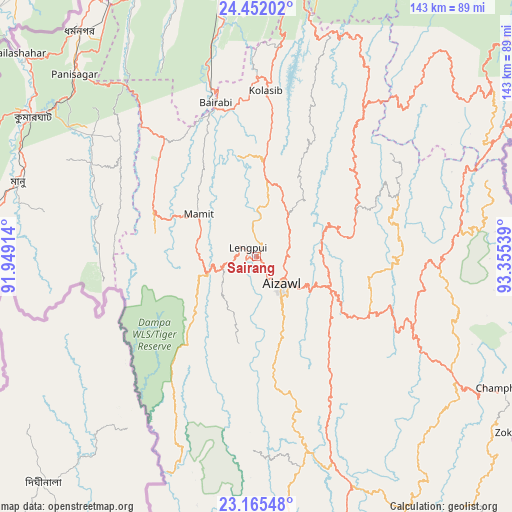
Sairang GPS coordinates[2]
23° 48' 37.224" North, 92° 39' 8.136" East
| Map corner | latitude | longitude |
|---|---|---|
| Upper-left | 24.45202°, | 91.94914° |
| Center: | 23.81034°, | 92.65226° |
| Lower-right: | 23.16548°, | 93.35539° |
| Map W x H: | 143×143.1 km | = 88.9×88.9mi |
| max Lat: | 34.9274° ⇑43% North |
| Sairang: | 23.81034° |
| min Lat: | ⇓57% South 8.09008° |
| min Long | Sairang | max Long |
| 68.82655° | 92.65226° | 96.81° |
| W 97.4%⇐ | ⇒2.6% E |
Elevation
Elevation of Sairang is 111 m = 364 ft, and this is 184.6 m = 606 ft below average elevation for this country.
| Max E: |
3681 m = 12077 ft | 66.3% |
| Avg. | 295.6 m = 970 ft | |
| Sairang | 111 m = 364 ft | |
Min E: |
1 m = 3 ft | 33.7% |
See also: India elevation on elevation.city.
Geographical zone
Sairang is located in North temperate zone (between Tropic of Cancer and the Arctic Circle). Distance of this Northern Tropic circle is 41.5 km =25.8 mi to South.| Distance of | km | miles | from Sairang |
|---|---|---|---|
| North Pole | 7359.6 | 4573 | to North |
| Arctic Circle | 4753.7 | 2953.8 | to North |
| Tropic Cancer | 41.5 | 25.8 | to South |
| Equator | 2647.5 | 1645.1 | to South |


Nearby cities:
15 places around Sairang: (largest is in red/bold)
• Aizawl
11.2 km =7 mi,  143°
143°
• Darlawn
35.7 km =22.2 mi,  50°
50°
• Dharmanagar
79.1 km =49.2 mi,  321°
321°
• Kailāshahar
87.7 km =54.5 mi,  311°
311°
• Kamalpur
93.5 km =58.1 mi,  297°
297°
• Khawhai
68.3 km =42.4 mi,  134°
134°
• Kolasib
46.1 km =28.6 mi,  3°
3°
• Lāla
82.8 km =51.4 mi,  357°
357°
• Mamit
21 km =13 mi, 308°
• North Vanlaiphai
86.4 km =53.7 mi,  150°
150°
• Pherzawl
74.1 km =46 mi, 47°
• Serchhīp
60.8 km =37.8 mi,  160°
160°
• Sāitlaw
19.6 km =12.2 mi,  336°
336°
• Thenzawl
55.8 km =34.7 mi,  169°
169°
• Āmbāsa
82.3 km =51.1 mi,  279°
279°
Sources, notices
• [Note1] Compared only with cities in India existing in our database
• [Src1] Map data: © OpenStreetMap contributors (CC-BY-SA)
• [Src2] Other city data from geonames.org with taken over terms of usage.
• [Src3] Geographical zone / Annual Mean Temperature by Robert A. Rohde @ Wikipedia
