Bodri geodata
Bodri (Madhya Pradesh) is a populated place; located in India in Asia/Kolkata (GMT+5.5) time zone. With population of 14,491 people, there are 2512 cities with bigger population in this country. Compared to other cities in India, 52.6% of cities are located further ↓South; 74.5% of cities are located further ←West and 82.7% of cities have lower elevation than Bodri. Note1


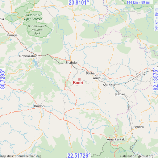
Bodri GPS coordinates[2]
23° 9' 54.864" North, 81° 25' 57.432" East
| Map corner | latitude | longitude |
|---|---|---|
| Upper-left | 23.8101°, | 80.7295° |
| Center: | 23.16524°, | 81.43262° |
| Lower-right: | 22.51726°, | 82.13575° |
| Map W x H: | 143.8×143.8 km | = 89.4×89.4mi |
| max Lat: | 34.9274° ⇑47.4% North |
| Bodri: | 23.16524° |
| min Lat: | ⇓52.6% South 8.09008° |
| min Long | Bodri | max Long |
| 68.82655° | 81.43262° | 96.81° |
| W 74.5%⇐ | ⇒25.5% E |
Elevation
Elevation of Bodri is 503 m = 1650 ft, and this is 207.4 m = 680 ft above average elevation for this country.
| Max E: |
3681 m = 12077 ft | 17.3% |
| Bodri | 503 m 1650 ft | |
| Avg. | 295.6 m = 970 ft | |
Min E: |
1 m = 3 ft | 82.7% |
See also: India elevation on elevation.city.
Geographical zone
Bodri is located in North Torrid zone (between Equator and Tropic of Cancer). Distance of this Northern Tropic circle is 30.2 km =18.8 mi to North.| Distance of | km | miles | from Bodri |
|---|---|---|---|
| North Pole | 7431.3 | 4617.6 | to North |
| Arctic Circle | 4825.4 | 2998.4 | to North |
| Tropic Cancer | 30.2 | 18.8 | to North |
| Equator | 2575.7 | 1600.5 | to South |


Nearby cities:
15 places around Bodri: (largest is in red/bold)
• Amarkantak
64 km =39.8 mi,  148°
148°
• Anūppur
27.3 km =17 mi,  104°
104°
• Beohāri
95.7 km =59.5 mi,  356°
356°
• Burhar
11.6 km =7.2 mi,  61°
61°
• Chandia
91.8 km =57 mi,  306°
306°
• Dindori
43.8 km =27.2 mi,  235°
235°
• Gaurela
66.2 km =41.1 mi,  133°
133°
• Jaisinghnagar
58 km =36 mi, 355°
• Kotma
56 km =34.8 mi,  85°
85°
• Pasān
86.1 km =53.5 mi,  114°
114°
• Pendra
69.2 km =43 mi, 128°
• Pāli
45.5 km =28.3 mi,  299°
299°
• Shahdol
16 km =9.9 mi,  333°
333°
• Shāhpur
46.6 km =29 mi,  250°
250°
• Umaria
72.8 km =45.2 mi, 303°
Sources, notices
• [Note1] Compared only with cities in India existing in our database
• [Src1] Map data: © OpenStreetMap contributors (CC-BY-SA)
• [Src2] Other city data from geonames.org with taken over terms of usage.
• [Src3] Geographical zone / Annual Mean Temperature by Robert A. Rohde @ Wikipedia
