Burhar geodata
Burhar (Madhya Pradesh) is a populated place; located in India in Asia/Kolkata (GMT+5.5) time zone. With population of 18,191 people, there are 2188 cities with bigger population in this country. Compared to other cities in India, 53.1% of cities are located further ↓South; 74.8% of cities are located further ←West and 81.8% of cities have lower elevation than Burhar. Note1


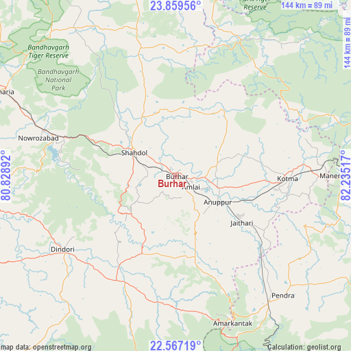
Burhar GPS coordinates[2]
23° 12' 53.784" North, 81° 31' 55.344" East
| Map corner | latitude | longitude |
|---|---|---|
| Upper-left | 23.85956°, | 80.82892° |
| Center: | 23.21494°, | 81.53204° |
| Lower-right: | 22.56719°, | 82.23517° |
| Map W x H: | 143.7×143.7 km | = 89.3×89.3mi |
| max Lat: | 34.9274° ⇑46.9% North |
| Burhar: | 23.21494° |
| min Lat: | ⇓53.1% South 8.09008° |
| min Long | Burhar | max Long |
| 68.82655° | 81.53204° | 96.81° |
| W 74.8%⇐ | ⇒25.2% E |
Elevation
Elevation of Burhar is 486 m = 1594 ft, and this is 190.4 m = 625 ft above average elevation for this country.
| Max E: |
3681 m = 12077 ft | 18.2% |
| Burhar | 486 m 1594 ft | |
| Avg. | 295.6 m = 970 ft | |
Min E: |
1 m = 3 ft | 81.8% |
See also: India elevation on elevation.city.
Geographical zone
Burhar is located in North Torrid zone (between Equator and Tropic of Cancer). Distance of this Northern Tropic circle is 24.7 km =15.3 mi to North.| Distance of | km | miles | from Burhar |
|---|---|---|---|
| North Pole | 7425.8 | 4614.2 | to North |
| Arctic Circle | 4819.9 | 2994.9 | to North |
| Tropic Cancer | 24.7 | 15.3 | to North |
| Equator | 2581.3 | 1603.9 | to South |


Nearby cities:
15 places around Burhar: (largest is in red/bold)
• Amarkantak
64.4 km =40 mi,  158°
158°
• Anūppur
20.4 km =12.7 mi,  127°
127°
• Beohāri
91.3 km =56.7 mi,  350°
350°
• Bodri
11.6 km =7.2 mi,  241°
241°
• Chandia
97.3 km =60.5 mi,  300°
300°
• Dindori
55.4 km =34.4 mi, 236°
• Gaurela
63.6 km =39.5 mi,  143°
143°
• Jaisinghnagar
54.3 km =33.7 mi,  344°
344°
• Kotma
45.7 km =28.4 mi,  91°
91°
• Pasān
79.7 km =49.5 mi,  121°
121°
• Pendra
65.6 km =40.8 mi, 138°
• Pāli
52.6 km =32.7 mi,  288°
288°
• Shahdol
19.5 km =12.1 mi, 296°
• Shāhpur
58 km =36 mi,  248°
248°
• Umaria
78.8 km =49 mi, 295°
Sources, notices
• [Note1] Compared only with cities in India existing in our database
• [Src1] Map data: © OpenStreetMap contributors (CC-BY-SA)
• [Src2] Other city data from geonames.org with taken over terms of usage.
• [Src3] Geographical zone / Annual Mean Temperature by Robert A. Rohde @ Wikipedia
