Allāpalli geodata
Allāpalli (Maharashtra) is a populated place; located in India in Asia/Kolkata (GMT+5.5) time zone. With population of 10,772 people, there are 2860 cities with bigger population in this country. Compared to other cities in India, 67.1% of cities are located further ↑North; 68.2% of cities are located further ←West and 60.8% of cities have higher elevation than Allāpalli. Note1


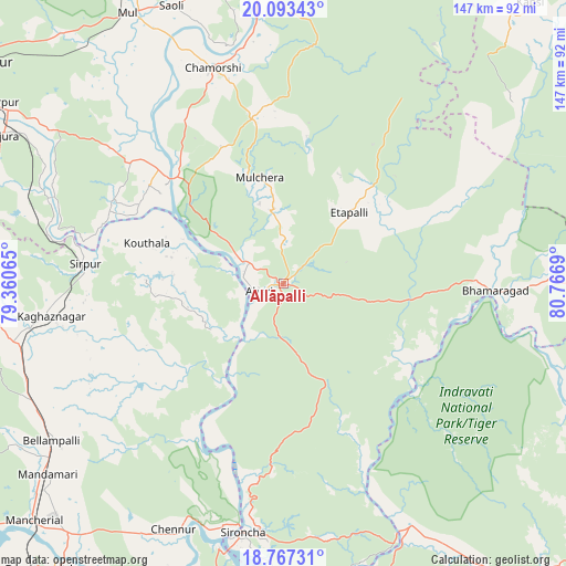
Allāpalli GPS coordinates[2]
19° 25' 54.192" North, 80° 3' 49.572" East
| Map corner | latitude | longitude |
|---|---|---|
| Upper-left | 20.09343°, | 79.36065° |
| Center: | 19.43172°, | 80.06377° |
| Lower-right: | 18.76731°, | 80.7669° |
| Map W x H: | 147.5×147.5 km | = 91.7×91.7mi |
| max Lat: | 34.9274° ⇑67.1% North |
| Allāpalli: | 19.43172° |
| min Lat: | ⇓32.9% South 8.09008° |
| min Long | Allāpalli | max Long |
| 68.82655° | 80.06377° | 96.81° |
| W 68.2%⇐ | ⇒31.8% E |
Elevation
Elevation of Allāpalli is 144 m = 472 ft, and this is 151.6 m = 497 ft below average elevation for this country.
| Max E: |
3681 m = 12077 ft | 60.8% |
| Avg. | 295.6 m = 970 ft | |
| Allāpalli | 144 m = 472 ft | |
Min E: |
1 m = 3 ft | 39.2% |
See also: India elevation on elevation.city.
Geographical zone
Allāpalli is located in North Torrid zone (between Equator and Tropic of Cancer). Distance of this Northern Tropic circle is 445.3 km =276.7 mi to North.| Distance of | km | miles | from Allāpalli |
|---|---|---|---|
| North Pole | 7846.5 | 4875.6 | to North |
| Arctic Circle | 5240.6 | 3256.4 | to North |
| Tropic Cancer | 445.3 | 276.7 | to North |
| Equator | 2160.6 | 1342.5 | to South |


Nearby cities:
15 places around Allāpalli: (largest is in red/bold)
• Ahiri
6.6 km =4.1 mi,  252°
252°
• Asifābād
82.2 km =51.1 mi,  264°
264°
• Ballālpur
88.2 km =54.8 mi,  301°
301°
• Bellampalli
73.1 km =45.4 mi,  235°
235°
• Kagaznāgār
63.7 km =39.6 mi, 259°
• Kothāpet
61.5 km =38.2 mi, 261°
• Mancherāl
91.3 km =56.7 mi,  226°
226°
• Mandamarri
80.7 km =50.1 mi, 230°
• Manthani
96.4 km =59.9 mi,  205°
205°
• Mūl
81.6 km =50.7 mi,  330°
330°
• Nāspur
90.8 km =56.4 mi,  224°
224°
• Ramagundam
97.5 km =60.6 mi, 219°
• Rājūra
82.8 km =51.4 mi, 297°
• Rāmgundam
95.1 km =59.1 mi, 222°
• Sirpur
51.5 km =32 mi,  275°
275°
Sources, notices
• [Note1] Compared only with cities in India existing in our database
• [Src1] Map data: © OpenStreetMap contributors (CC-BY-SA)
• [Src2] Other city data from geonames.org with taken over terms of usage.
• [Src3] Geographical zone / Annual Mean Temperature by Robert A. Rohde @ Wikipedia
