Rājūra geodata
Rājūra (Maharashtra) is a populated place; located in India in Asia/Kolkata (GMT+5.5) time zone. With population of 28,881 people, there are 1501 cities with bigger population in this country. Compared to other cities in India, 66% of cities are located further ↑North; 62.4% of cities are located further ←West and 51.7% of cities have higher elevation than Rājūra. Note1


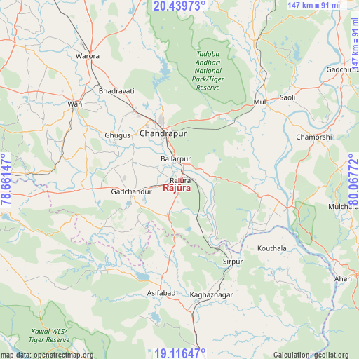
Rājūra GPS coordinates[2]
19° 46' 46.092" North, 79° 21' 52.524" East
| Map corner | latitude | longitude |
|---|---|---|
| Upper-left | 20.43973°, | 78.66147° |
| Center: | 19.77947°, | 79.36459° |
| Lower-right: | 19.11647°, | 80.06772° |
| Map W x H: | 147.1×147.1 km | = 91.4×91.4mi |
| max Lat: | 34.9274° ⇑66% North |
| Rājūra: | 19.77947° |
| min Lat: | ⇓34% South 8.09008° |
| min Long | Rājūra | max Long |
| 68.82655° | 79.36459° | 96.81° |
| W 62.4%⇐ | ⇒37.6% E |
Elevation
Elevation of Rājūra is 193 m = 633 ft, and this is 102.6 m = 337 ft below average elevation for this country.
| Max E: |
3681 m = 12077 ft | 51.7% |
| Avg. | 295.6 m = 970 ft | |
| Rājūra | 193 m = 633 ft | |
Min E: |
1 m = 3 ft | 48.3% |
See also: India elevation on elevation.city.
Geographical zone
Rājūra is located in North Torrid zone (between Equator and Tropic of Cancer). Distance of this Northern Tropic circle is 406.6 km =252.6 mi to North.| Distance of | km | miles | from Rājūra |
|---|---|---|---|
| North Pole | 7807.8 | 4851.5 | to North |
| Arctic Circle | 5201.9 | 3232.3 | to North |
| Tropic Cancer | 406.6 | 252.6 | to North |
| Equator | 2199.3 | 1366.6 | to South |


Nearby cities:
15 places around Rājūra: (largest is in red/bold)
• Ahiri
78.3 km =48.7 mi,  121°
121°
• Asifābād
47.6 km =29.6 mi,  190°
190°
• Ballālpur
7.8 km =4.8 mi,  345°
345°
• Bellampalli
81.6 km =50.7 mi,  170°
170°
• Chānda
20.4 km =12.7 mi,  339°
339°
• Chāndur
20.8 km =12.9 mi,  256°
256°
• Durgāpur
25.9 km =16.1 mi, 345°
• Ghugus
31.8 km =19.8 mi,  303°
303°
• Kagaznāgār
50.9 km =31.6 mi, 167°
• Kothāpet
49.2 km =30.6 mi, 165°
• Mūl
46 km =28.6 mi,  45°
45°
• Rājur
61.5 km =38.2 mi,  306°
306°
• Sirpur
40 km =24.9 mi,  146°
146°
• Wani
52.8 km =32.8 mi, 305°
• Warora
62.7 km =39 mi,  322°
322°
Sources, notices
• [Note1] Compared only with cities in India existing in our database
• [Src1] Map data: © OpenStreetMap contributors (CC-BY-SA)
• [Src2] Other city data from geonames.org with taken over terms of usage.
• [Src3] Geographical zone / Annual Mean Temperature by Robert A. Rohde @ Wikipedia
