Ahiri geodata
Ahiri (Maharashtra) is a populated place; located in India in Asia/Kolkata (GMT+5.5) time zone. With population of 14,384 people, there are 2524 cities with bigger population in this country. Compared to other cities in India, 67.1% of cities are located further ↑North; 67.9% of cities are located further ←West and 61.5% of cities have higher elevation than Ahiri. Note1


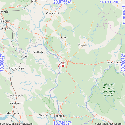
Ahiri GPS coordinates[2]
19° 24' 49.896" North, 80° 0' 12.924" East
| Map corner | latitude | longitude |
|---|---|---|
| Upper-left | 20.07564°, | 79.30047° |
| Center: | 19.41386°, | 80.00359° |
| Lower-right: | 18.74937°, | 80.70672° |
| Map W x H: | 147.5×147.5 km | = 91.7×91.7mi |
| max Lat: | 34.9274° ⇑67.1% North |
| Ahiri: | 19.41386° |
| min Lat: | ⇓32.9% South 8.09008° |
| min Long | Ahiri | max Long |
| 68.82655° | 80.00359° | 96.81° |
| W 67.9%⇐ | ⇒32.1% E |
Elevation
Elevation of Ahiri is 140 m = 459 ft, and this is 155.6 m = 510 ft below average elevation for this country.
| Max E: |
3681 m = 12077 ft | 61.5% |
| Avg. | 295.6 m = 970 ft | |
| Ahiri | 140 m = 459 ft | |
Min E: |
1 m = 3 ft | 38.5% |
See also: India elevation on elevation.city.
Geographical zone
Ahiri is located in North Torrid zone (between Equator and Tropic of Cancer). Distance of this Northern Tropic circle is 447.3 km =277.9 mi to North.| Distance of | km | miles | from Ahiri |
|---|---|---|---|
| North Pole | 7848.4 | 4876.8 | to North |
| Arctic Circle | 5242.6 | 3257.6 | to North |
| Tropic Cancer | 447.3 | 277.9 | to North |
| Equator | 2158.6 | 1341.3 | to South |


Nearby cities:
15 places around Ahiri: (largest is in red/bold)
• Allāpalli
6.6 km =4.1 mi,  72°
72°
• Asifābād
75.7 km =47 mi,  265°
265°
• Ballālpur
84.1 km =52.3 mi,  304°
304°
• Bellampalli
66.8 km =41.5 mi,  233°
233°
• Kagaznāgār
57.1 km =35.5 mi,  260°
260°
• Kothāpet
55 km =34.2 mi, 262°
• Mancherāl
85.4 km =53.1 mi, 225°
• Mandamarri
74.7 km =46.4 mi, 228°
• Manthani
92 km =57.2 mi,  202°
202°
• Mūl
80.5 km =50 mi,  334°
334°
• Nāspur
85 km =52.8 mi,  222°
222°
• Ramagundam
92 km =57.2 mi, 217°
• Rājūra
78.3 km =48.7 mi, 301°
• Rāmgundam
89.5 km =55.6 mi, 220°
• Sirpur
45.5 km =28.3 mi,  279°
279°
Sources, notices
• [Note1] Compared only with cities in India existing in our database
• [Src1] Map data: © OpenStreetMap contributors (CC-BY-SA)
• [Src2] Other city data from geonames.org with taken over terms of usage.
• [Src3] Geographical zone / Annual Mean Temperature by Robert A. Rohde @ Wikipedia
