Ballālpur geodata
Ballālpur (Maharashtra) is a section of populated place; located in India in Asia/Kolkata (GMT+5.5) time zone. With population of 92,146 people, there are 483 cities with bigger population in this country. Compared to other cities in India, 65.8% of cities are located further ↑North; 62.3% of cities are located further ←West and 52.4% of cities have higher elevation than Ballālpur. Note1


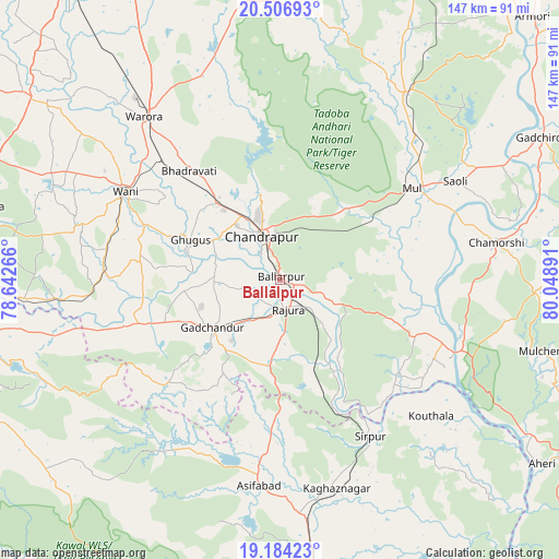
Ballālpur GPS coordinates[2]
19° 50' 49.056" North, 79° 20' 44.808" East
| Map corner | latitude | longitude |
|---|---|---|
| Upper-left | 20.50693°, | 78.64266° |
| Center: | 19.84696°, | 79.34578° |
| Lower-right: | 19.18423°, | 80.04891° |
| Map W x H: | 147.1×147.1 km | = 91.4×91.4mi |
| max Lat: | 34.9274° ⇑65.8% North |
| Ballālpur: | 19.84696° |
| min Lat: | ⇓34.2% South 8.09008° |
| min Long | Ballālpur | max Long |
| 68.82655° | 79.34578° | 96.81° |
| W 62.3%⇐ | ⇒37.7% E |
Elevation
Elevation of Ballālpur is 188 m = 617 ft, and this is 107.6 m = 353 ft below average elevation for this country.
| Max E: |
3681 m = 12077 ft | 52.4% |
| Avg. | 295.6 m = 970 ft | |
| Ballālpur | 188 m = 617 ft | |
Min E: |
1 m = 3 ft | 47.6% |
See also: Ballālpur elevation on elevation.city.
Geographical zone
Ballālpur is located in North Torrid zone (between Equator and Tropic of Cancer). Distance of this Northern Tropic circle is 399.1 km =248 mi to North.| Distance of | km | miles | from Ballālpur |
|---|---|---|---|
| North Pole | 7800.3 | 4846.9 | to North |
| Arctic Circle | 5194.4 | 3227.6 | to North |
| Tropic Cancer | 399.1 | 248 | to North |
| Equator | 2206.8 | 1371.2 | to South |


Nearby cities:
15 places around Ballālpur: (largest is in red/bold)
• Ahiri
84.1 km =52.3 mi,  124°
124°
• Asifābād
54.7 km =34 mi,  186°
186°
• Chānda
12.7 km =7.9 mi,  335°
335°
• Chāndur
22.1 km =13.7 mi,  235°
235°
• Durgāpur
18.2 km =11.3 mi,  345°
345°
• Ghugus
26.5 km =16.5 mi,  292°
292°
• Kagaznāgār
58.7 km =36.5 mi,  167°
167°
• Kothāpet
56.9 km =35.4 mi, 165°
• Mūl
42.7 km =26.5 mi,  54°
54°
• Rājur
55.7 km =34.6 mi,  301°
301°
• Rājūra
7.8 km =4.8 mi, 165°
• Sirpur
47.4 km =29.5 mi,  149°
149°
• Wani
47.1 km =29.3 mi, 299°
• Warora
55.6 km =34.5 mi,  319°
319°
• Ādilābād
87 km =54.1 mi,  257°
257°
Sources, notices
• [Note1] Compared only with cities in India existing in our database
• [Src1] Map data: © OpenStreetMap contributors (CC-BY-SA)
• [Src2] Other city data from geonames.org with taken over terms of usage.
• [Src3] Geographical zone / Annual Mean Temperature by Robert A. Rohde @ Wikipedia
