Mehekar geodata
Mehekar (Maharashtra) is a populated place; located in India in Asia/Kolkata (GMT+5.5) time zone. With population of 41,137 people, there are 1078 cities with bigger population in this country. Compared to other cities in India, 64.7% of cities are located further ↑North; 67.7% of cities are located further →East and 85.7% of cities have lower elevation than Mehekar. Note1


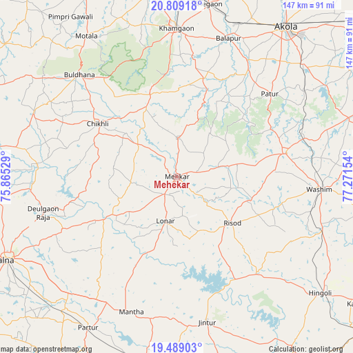
Mehekar GPS coordinates[2]
20° 9' 1.8" North, 76° 34' 6.276" East
| Map corner | latitude | longitude |
|---|---|---|
| Upper-left | 20.80918°, | 75.86529° |
| Center: | 20.1505°, | 76.56841° |
| Lower-right: | 19.48903°, | 77.27154° |
| Map W x H: | 146.8×146.8 km | = 91.2×91.2mi |
| max Lat: | 34.9274° ⇑64.7% North |
| Mehekar: | 20.1505° |
| min Lat: | ⇓35.3% South 8.09008° |
| min Long | Mehekar | max Long |
| 68.82655° | 76.56841° | 96.81° |
| W 32.3%⇐ | ⇒67.7% E |
Elevation
Elevation of Mehekar is 559 m = 1834 ft, and this is 263.4 m = 864 ft above average elevation for this country.
| Max E: |
3681 m = 12077 ft | 14.3% |
| Mehekar | 559 m 1834 ft | |
| Avg. | 295.6 m = 970 ft | |
Min E: |
1 m = 3 ft | 85.7% |
See also: Mehekar elevation on elevation.city.
Geographical zone
Mehekar is located in North Torrid zone (between Equator and Tropic of Cancer). Distance of this Northern Tropic circle is 365.4 km =227 mi to North.| Distance of | km | miles | from Mehekar |
|---|---|---|---|
| North Pole | 7766.5 | 4825.9 | to North |
| Arctic Circle | 5160.6 | 3206.6 | to North |
| Tropic Cancer | 365.4 | 227 | to North |
| Equator | 2240.5 | 1392.2 | to South |


Nearby cities:
15 places around Mehekar: (largest is in red/bold)
• Akola
76.6 km =47.6 mi,  35°
35°
• Buldāna
58.1 km =36.1 mi,  316°
316°
• Bālāpur
61.2 km =38 mi,  20°
20°
• Chikhli
39.3 km =24.4 mi,  304°
304°
• Deūlgaon Rāja
57.4 km =35.7 mi,  255°
255°
• Hingoli
77.1 km =47.9 mi,  128°
128°
• Jintūr
61.2 km =38 mi,  168°
168°
• Khāmgaon
61.9 km =38.5 mi,  359°
359°
• Lonār
19 km =11.8 mi,  195°
195°
• Nāndūra Buzurg
76.9 km =47.8 mi,  351°
351°
• Partūr
71.5 km =44.4 mi,  211°
211°
• Pātūr
51.7 km =32.1 mi,  48°
48°
• Risod
30 km =18.6 mi, 130°
• Shegaon
72.7 km =45.2 mi,  10°
10°
• Wāshīm
59.1 km =36.7 mi,  94°
94°
Sources, notices
• [Note1] Compared only with cities in India existing in our database
• [Src1] Map data: © OpenStreetMap contributors (CC-BY-SA)
• [Src2] Other city data from geonames.org with taken over terms of usage.
• [Src3] Geographical zone / Annual Mean Temperature by Robert A. Rohde @ Wikipedia
