Ruwāndiz geodata
Ruwāndiz (Arbīl) is a seat of a second-order administrative division; located in Iraq in Asia/Baghdad (GMT+3) time zone. With population of 22,943 people, there are 63 cities with bigger population in this country. Compared to other cities in Iraq, 88% of cities are located further ↓South; 52.8% of cities are located further ←West and 88% of cities have lower elevation than Ruwāndiz. Note1


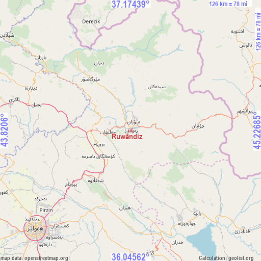
Ruwāndiz GPS coordinates[2]
36° 36' 43.452" North, 44° 31' 25.392" East
| Map corner | latitude | longitude |
|---|---|---|
| Upper-left | 37.17439°, | 43.8206° |
| Center: | 36.61207°, | 44.52372° |
| Lower-right: | 36.04562°, | 45.22685° |
| Map W x H: | 125.5×125.5 km | = 78×78mi |
| max Lat: | 37.22781° ⇑12% North |
| Ruwāndiz: | 36.61207° |
| min Lat: | ⇓88% South 29.97421° |
| min Long | Ruwāndiz | max Long |
| 40.28586° | 44.52372° | 48.47309° |
| W 52.8%⇐ | ⇒47.2% E |
Elevation
Elevation of Ruwāndiz is 797 m = 2615 ft, and this is 504 m = 1654 ft above average elevation for this country.
| Max E: |
1316 m = 4318 ft | 12% |
| Ruwāndiz | 797 m 2615 ft | |
| Avg. | 293 m = 961 ft | |
Min E: |
1 m = 3 ft | 88% |
See also: Iraq elevation on elevation.city.
Geographical zone
Ruwāndiz is located in North temperate zone (between Tropic of Cancer and the Arctic Circle). Distance of this Northern Tropic circle is 1465 km =910.3 mi to South.| Distance of | km | miles | from Ruwāndiz |
|---|---|---|---|
| North Pole | 5936.2 | 3688.6 | to North |
| Arctic Circle | 3330.3 | 2069.4 | to North |
| Tropic Cancer | 1465 | 910.3 | to South |
| Equator | 4070.9 | 2529.5 | to South |


Nearby cities:
15 places around Ruwāndiz: (largest is in red/bold)
• Beḧirke
54.7 km =34 mi,  232°
232°
• Choman
32.6 km =20.3 mi,  85°
85°
• Dare Tû
68.6 km =42.6 mi,  217°
217°
• Erbil
66.1 km =41.1 mi, 223°
• Hīrān
37.3 km =23.2 mi,  184°
184°
• Kasnazān
57.6 km =35.8 mi, 217°
• Koysinceq
59.6 km =37 mi,  170°
170°
• Mêrgasur
32.2 km =20 mi,  322°
322°
• Nāḩiyat Hīrān
37.2 km =23.1 mi, 184°
• Qeładizê
72.3 km =44.9 mi,  131°
131°
• Shaqlāwah
29.1 km =18.1 mi, 217°
• Soran
4.9 km =3 mi,  21°
21°
• Ṟaniye
51 km =31.7 mi,  141°
141°
• ‘Aqrah
58.5 km =36.4 mi,  286°
286°
• ‘Aynkāwah
63.6 km =39.5 mi, 228°
Sources, notices
• [Note1] Compared only with cities in Iraq existing in our database
• [Src1] Map data: © OpenStreetMap contributors (CC-BY-SA)
• [Src2] Other city data from geonames.org with taken over terms of usage.
• [Src3] Geographical zone / Annual Mean Temperature by Robert A. Rohde @ Wikipedia
