Hīrān geodata
Hīrān (Arbīl) is a seat of a third-order administrative division; located in Iraq in Asia/Baghdad (GMT+3) time zone. In our database, there are 71 cities with bigger population. Compared to other cities in Iraq, 81% of cities are located further ↓South; 51.4% of cities are located further ←West and 92.3% of cities have lower elevation than Hīrān. Note1


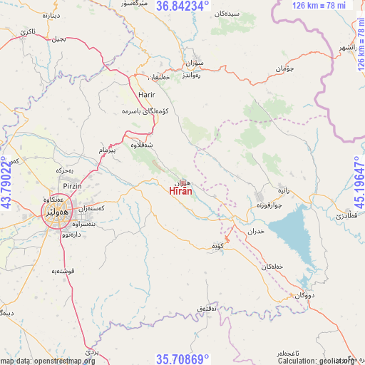
Hīrān GPS coordinates[2]
36° 16' 39.252" North, 44° 29' 36.024" East
| Map corner | latitude | longitude |
|---|---|---|
| Upper-left | 36.84234°, | 43.79022° |
| Center: | 36.27757°, | 44.49334° |
| Lower-right: | 35.70869°, | 45.19647° |
| Map W x H: | 126.1×126.1 km | = 78.4×78.4mi |
| max Lat: | 37.22781° ⇑19% North |
| Hīrān: | 36.27757° |
| min Lat: | ⇓81% South 29.97421° |
| min Long | Hīrān | max Long |
| 40.28586° | 44.49334° | 48.47309° |
| W 51.4%⇐ | ⇒48.6% E |
Elevation
Elevation of Hīrān is 906 m = 2972 ft, and this is 613 m = 2011 ft above average elevation for this country.
| Max E: |
1316 m = 4318 ft | 7.7% |
| Hīrān | 906 m 2972 ft | |
| Avg. | 293 m = 961 ft | |
Min E: |
1 m = 3 ft | 92.3% |
See also: Iraq elevation on elevation.city.
Geographical zone
Hīrān is located in North temperate zone (between Tropic of Cancer and the Arctic Circle). Distance of this Northern Tropic circle is 1427.8 km =887.2 mi to South.| Distance of | km | miles | from Hīrān |
|---|---|---|---|
| North Pole | 5973.4 | 3711.7 | to North |
| Arctic Circle | 3367.5 | 2092.5 | to North |
| Tropic Cancer | 1427.8 | 887.2 | to South |
| Equator | 4033.7 | 2506.4 | to South |


Nearby cities:
15 places around Hīrān: (largest is in red/bold)
• Beḧirke
41.3 km =25.7 mi,  275°
275°
• Choman
53.3 km =33.1 mi,  41°
41°
• Dare Tû
42.6 km =26.5 mi,  245°
245°
• Dukan
57.3 km =35.6 mi,  132°
132°
• Erbil
44.4 km =27.6 mi,  256°
256°
• Kasnazān
33.5 km =20.8 mi, 255°
• Koysinceq
24.8 km =15.4 mi,  150°
150°
• Nāḩiyat Hīrān
0.5 km =0.3 mi,  288°
288°
• Qeładizê
58.1 km =36.1 mi,  100°
100°
• Qushtepe
51.1 km =31.8 mi,  233°
233°
• Ruwāndiz
37.3 km =23.2 mi,  4°
4°
• Shaqlāwah
20.6 km =12.8 mi,  313°
313°
• Soran
42 km =26.1 mi,  6°
6°
• Ṟaniye
35 km =21.7 mi,  94°
94°
• ‘Aynkāwah
45 km =28 mi, 263°
Sources, notices
• [Note1] Compared only with cities in Iraq existing in our database
• [Src1] Map data: © OpenStreetMap contributors (CC-BY-SA)
• [Src2] Other city data from geonames.org with taken over terms of usage.
• [Src3] Geographical zone / Annual Mean Temperature by Robert A. Rohde @ Wikipedia
