‘Anah geodata
‘Anah (Anbar) is a seat of a second-order administrative division; located in Iraq in Asia/Baghdad (GMT+3) time zone. With population of 27,000 people, there are 57 cities with bigger population in this country. Compared to other cities in Iraq, 50% of cities are located further ↓South; 95.8% of cities are located further →East and 52.8% of cities have lower elevation than ‘Anah. Note1


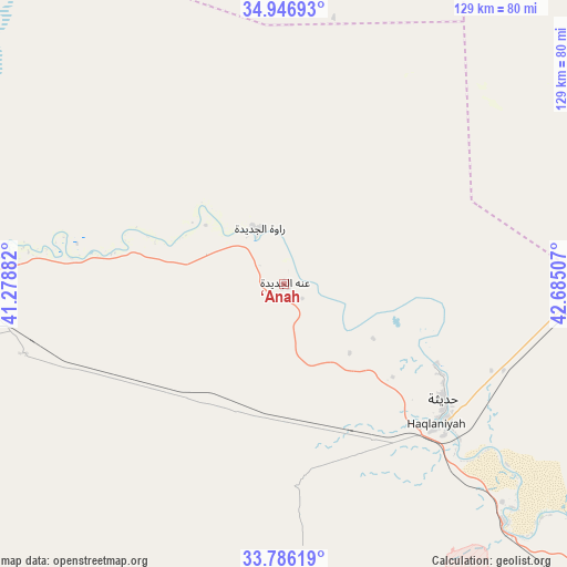
‘Anah GPS coordinates[2]
34° 22' 6.852" North, 41° 58' 54.984" East
| Map corner | latitude | longitude |
|---|---|---|
| Upper-left | 34.94693°, | 41.27882° |
| Center: | 34.36857°, | 41.98194° |
| Lower-right: | 33.78619°, | 42.68507° |
| Map W x H: | 129.1×129.1 km | = 80.2×80.2mi |
| max Lat: | 37.22781° ⇑50% North |
| ‘Anah: | 34.36857° |
| min Lat: | ⇓50% South 29.97421° |
| min Long | ‘Anah | max Long |
| 40.28586° | 41.98194° | 48.47309° |
| W 4.2%⇐ | ⇒95.8% E |
Elevation
Elevation of ‘Anah is 177 m = 581 ft, and this is 116 m = 381 ft below average elevation for this country.
| Max E: |
1316 m = 4318 ft | 47.2% |
| Avg. | 293 m = 961 ft | |
| ‘Anah | 177 m = 581 ft | |
Min E: |
1 m = 3 ft | 52.8% |
See also: Iraq elevation on elevation.city.
Geographical zone
‘Anah is located in North temperate zone (between Tropic of Cancer and the Arctic Circle). Distance of this Northern Tropic circle is 1215.5 km =755.3 mi to South.| Distance of | km | miles | from ‘Anah |
|---|---|---|---|
| North Pole | 6185.6 | 3843.6 | to North |
| Arctic Circle | 3579.7 | 2224.3 | to North |
| Tropic Cancer | 1215.5 | 755.3 | to South |
| Equator | 3821.4 | 2374.5 | to South |


Nearby cities:
15 places around ‘Anah: (largest is in red/bold)
• Ad Dawr
166.4 km =103.4 mi,  86°
86°
• Al Qā’im
91.1 km =56.6 mi,  271°
271°
• Al Ḩaqlānīyah
47 km =29.2 mi,  131°
131°
• Al Ḩaḑar
150.4 km =93.5 mi,  27°
27°
• Al ‘Abbāsī
178.5 km =110.9 mi,  55°
55°
• Al ‘Awjah
161.6 km =100.4 mi,  83°
83°
• Ash Sharqāt
170.9 km =106.2 mi,  41°
41°
• Bayjī
151.3 km =94 mi,  65°
65°
• Hīt
112.7 km =70 mi,  136°
136°
• Ramadi
161.5 km =100.4 mi, 130°
• Rāwah
13.9 km =8.6 mi,  335°
335°
• Sāmarrā’
176 km =109.4 mi,  96°
96°
• Tikrīt
157.9 km =98.1 mi, 79°
• Ḩadīthah
44.6 km =27.7 mi, 125°
• ‘Anat al Qadīmah
11.8 km =7.3 mi, 341°
Sources, notices
• [Note1] Compared only with cities in Iraq existing in our database
• [Src1] Map data: © OpenStreetMap contributors (CC-BY-SA)
• [Src2] Other city data from geonames.org with taken over terms of usage.
• [Src3] Geographical zone / Annual Mean Temperature by Robert A. Rohde @ Wikipedia
