Ramadi geodata
Ramadi (Anbar) is a seat of a first-order administrative division; located in Iraq in Asia/Baghdad (GMT+3) time zone. With population of 274,539 people, there are 17 cities with bigger population in this country. Compared to other cities in Iraq, 60.6% of cities are located further ↑North; 81% of cities are located further →East and 59.2% of cities have higher elevation than Ramadi. Note1


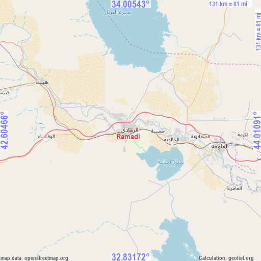
Ramadi GPS coordinates[2]
33° 25' 14.016" North, 43° 18' 28.008" East
| Map corner | latitude | longitude |
|---|---|---|
| Upper-left | 34.00543°, | 42.60466° |
| Center: | 33.42056°, | 43.30778° |
| Lower-right: | 32.83172°, | 44.01091° |
| Map W x H: | 130.5×130.5 km | = 81.1×81.1mi |
| max Lat: | 37.22781° ⇑60.6% North |
| Ramadi: | 33.42056° |
| min Lat: | ⇓39.4% South 29.97421° |
| min Long | Ramadi | max Long |
| 40.28586° | 43.30778° | 48.47309° |
| W 19%⇐ | ⇒81% E |
Elevation
Elevation of Ramadi is 53 m = 174 ft, and this is 240 m = 787 ft below average elevation for this country.
| Max E: |
1316 m = 4318 ft | 59.2% |
| Avg. | 293 m = 961 ft | |
| Ramadi | 53 m = 174 ft | |
Min E: |
1 m = 3 ft | 40.8% |
See also: Ramadi elevation on elevation.city.
Geographical zone
Ramadi is located in North temperate zone (between Tropic of Cancer and the Arctic Circle). Distance of this Northern Tropic circle is 1110.1 km =689.8 mi to South.| Distance of | km | miles | from Ramadi |
|---|---|---|---|
| North Pole | 6291 | 3909 | to North |
| Arctic Circle | 3685.2 | 2289.9 | to North |
| Tropic Cancer | 1110.1 | 689.8 | to South |
| Equator | 3716 | 2309 | to South |


Nearby cities:
15 places around Ramadi: (largest is in red/bold)
• Abū Ghurayb
82.4 km =51.2 mi,  98°
98°
• Ad Dujayl
98 km =60.9 mi,  61°
61°
• Al Fallūjah
45.1 km =28 mi, 100°
• Al Maḩmūdīyah
106.1 km =65.9 mi,  112°
112°
• Al Musayyib
116 km =72.1 mi,  127°
127°
• Al Ḩaqlānīyah
114.6 km =71.2 mi,  310°
310°
• Aţ Ţārmīyah
104.7 km =65.1 mi,  74°
74°
• Baghdad
101.9 km =63.3 mi, 95°
• Balad
101.8 km =63.3 mi,  49°
49°
• Hīt
50.6 km =31.4 mi,  298°
298°
• Karbala
111.7 km =69.4 mi,  143°
143°
• Nāḩīyat Saddat al Hindīyah
119.7 km =74.4 mi, 130°
• Sāmarrā’
101.4 km =63 mi,  31°
31°
• Ḩadīthah
117.2 km =72.8 mi, 312°
• ‘Ayn Tamr
96.4 km =59.9 mi,  169°
169°
Sources, notices
• [Note1] Compared only with cities in Iraq existing in our database
• [Src1] Map data: © OpenStreetMap contributors (CC-BY-SA)
• [Src2] Other city data from geonames.org with taken over terms of usage.
• [Src3] Geographical zone / Annual Mean Temperature by Robert A. Rohde @ Wikipedia
