Hīt geodata
Hīt (Anbar) is a seat of a second-order administrative division; located in Iraq in Asia/Baghdad (GMT+3) time zone. With population of 31,901 people, there are 50 cities with bigger population in this country. Compared to other cities in Iraq, 59.9% of cities are located further ↑North; 89.4% of cities are located further →East and 56.3% of cities have higher elevation than Hīt. Note1


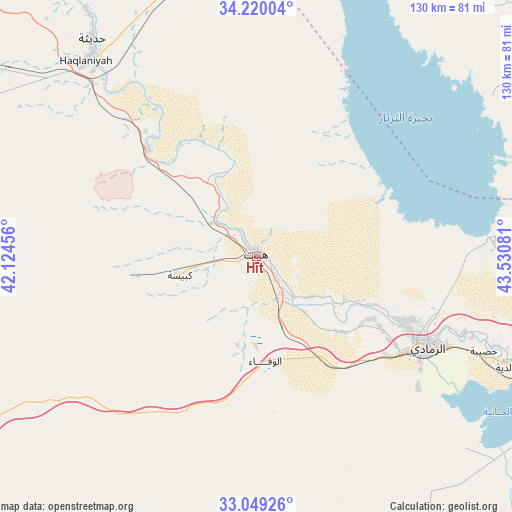
Hīt GPS coordinates[2]
33° 38' 11.904" North, 42° 49' 39.648" East
| Map corner | latitude | longitude |
|---|---|---|
| Upper-left | 34.22004°, | 42.12456° |
| Center: | 33.63664°, | 42.82768° |
| Lower-right: | 33.04926°, | 43.53081° |
| Map W x H: | 130.2×130.2 km | = 80.9×80.9mi |
| max Lat: | 37.22781° ⇑59.9% North |
| Hīt: | 33.63664° |
| min Lat: | ⇓40.1% South 29.97421° |
| min Long | Hīt | max Long |
| 40.28586° | 42.82768° | 48.47309° |
| W 10.6%⇐ | ⇒89.4% E |
Elevation
Elevation of Hīt is 61 m = 200 ft, and this is 232 m = 761 ft below average elevation for this country.
| Max E: |
1316 m = 4318 ft | 56.3% |
| Avg. | 293 m = 961 ft | |
| Hīt | 61 m = 200 ft | |
Min E: |
1 m = 3 ft | 43.7% |
See also: Iraq elevation on elevation.city.
Geographical zone
Hīt is located in North temperate zone (between Tropic of Cancer and the Arctic Circle). Distance of this Northern Tropic circle is 1134.1 km =704.7 mi to South.| Distance of | km | miles | from Hīt |
|---|---|---|---|
| North Pole | 6267 | 3894.1 | to North |
| Arctic Circle | 3661.1 | 2274.9 | to North |
| Tropic Cancer | 1134.1 | 704.7 | to South |
| Equator | 3740 | 2323.9 | to South |


Nearby cities:
15 places around Hīt: (largest is in red/bold)
• Abū Ghurayb
131.1 km =81.5 mi,  106°
106°
• Ad Dawr
127.3 km =79.1 mi,  44°
44°
• Ad Dujayl
132.1 km =82.1 mi,  79°
79°
• Al Fallūjah
94.4 km =58.7 mi, 109°
• Al Ḩaqlānīyah
65.9 km =40.9 mi,  319°
319°
• Al ‘Awjah
130 km =80.8 mi, 39°
• Balad
128.8 km =80 mi,  70°
70°
• Ramadi
50.6 km =31.4 mi,  118°
118°
• Rāwah
125.9 km =78.2 mi, 318°
• Sāmarrā’
115.7 km =71.9 mi,  57°
57°
• Tikrīt
134.1 km =83.3 mi, 35°
• Ḩadīthah
69.4 km =43.1 mi, 323°
• ‘Anah
112.7 km =70 mi, 316°
• ‘Anat al Qadīmah
123.4 km =76.7 mi, 318°
• ‘Ayn Tamr
133.9 km =83.2 mi,  152°
152°
Sources, notices
• [Note1] Compared only with cities in Iraq existing in our database
• [Src1] Map data: © OpenStreetMap contributors (CC-BY-SA)
• [Src2] Other city data from geonames.org with taken over terms of usage.
• [Src3] Geographical zone / Annual Mean Temperature by Robert A. Rohde @ Wikipedia
