Al Ḩaqlānīyah geodata
Al Ḩaqlānīyah (Anbar) is a seat of a third-order administrative division; located in Iraq in Asia/Baghdad (GMT+3) time zone. In our database, there are 71 cities with bigger population. Compared to other cities in Iraq, 52.8% of cities are located further ↑North; 95.1% of cities are located further →East and 50.7% of cities have higher elevation than Al Ḩaqlānīyah. Note1


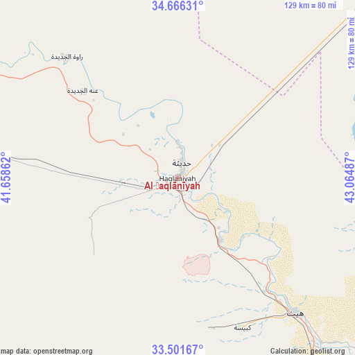
Al Ḩaqlānīyah GPS coordinates[2]
34° 5' 9.564" North, 42° 21' 42.264" East
| Map corner | latitude | longitude |
|---|---|---|
| Upper-left | 34.66631°, | 41.65862° |
| Center: | 34.08599°, | 42.36174° |
| Lower-right: | 33.50167°, | 43.06487° |
| Map W x H: | 129.5×129.5 km | = 80.5×80.5mi |
| max Lat: | 37.22781° ⇑52.8% North |
| Al Ḩaqlānīyah: | 34.08599° |
| min Lat: | ⇓47.2% South 29.97421° |
| min Long | Al Ḩaqlānīy | max Long |
| 40.28586° | 42.36174° | 48.47309° |
| W 4.9%⇐ | ⇒95.1% E |
Elevation
Elevation of Al Ḩaqlānīyah is 126 m = 413 ft, and this is 167 m = 548 ft below average elevation for this country.
| Max E: |
1316 m = 4318 ft | 50.7% |
| Avg. | 293 m = 961 ft | |
| Al Ḩaqlānīyah | 126 m = 413 ft | |
Min E: |
1 m = 3 ft | 49.3% |
See also: Iraq elevation on elevation.city.
Geographical zone
Al Ḩaqlānīyah is located in North temperate zone (between Tropic of Cancer and the Arctic Circle). Distance of this Northern Tropic circle is 1184.1 km =735.8 mi to South.| Distance of | km | miles | from Al Ḩaqlānīyah |
|---|---|---|---|
| North Pole | 6217.1 | 3863.1 | to North |
| Arctic Circle | 3611.2 | 2243.9 | to North |
| Tropic Cancer | 1184.1 | 735.8 | to South |
| Equator | 3790 | 2355 | to South |


Nearby cities:
15 places around Al Ḩaqlānīyah: (largest is in red/bold)
• Ad Dawr
137.8 km =85.6 mi,  72°
72°
• Al Fallūjah
155.1 km =96.4 mi,  121°
121°
• Al Qā’im
130.7 km =81.2 mi,  285°
285°
• Al Ḩaḑar
168.8 km =104.9 mi,  11°
11°
• Al ‘Awjah
135.4 km =84.1 mi, 68°
• Balad
164.5 km =102.2 mi,  92°
92°
• Bayjī
139.5 km =86.7 mi,  47°
47°
• Hīt
65.9 km =40.9 mi,  139°
139°
• Ramadi
114.6 km =71.2 mi,  130°
130°
• Rāwah
60 km =37.3 mi,  317°
317°
• Sāmarrā’
140.8 km =87.5 mi, 85°
• Tikrīt
134.5 km =83.6 mi,  64°
64°
• Ḩadīthah
5.8 km =3.6 mi, 14°
• ‘Anah
47 km =29.2 mi,  311°
311°
• ‘Anat al Qadīmah
57.5 km =35.7 mi, 317°
Sources, notices
• [Note1] Compared only with cities in Iraq existing in our database
• [Src1] Map data: © OpenStreetMap contributors (CC-BY-SA)
• [Src2] Other city data from geonames.org with taken over terms of usage.
• [Src3] Geographical zone / Annual Mean Temperature by Robert A. Rohde @ Wikipedia
